
2.3: Trade and Interaction in the Indian Ocean
- Page ID
- 154800
\( \newcommand{\vecs}[1]{\overset { \scriptstyle \rightharpoonup} {\mathbf{#1}} } \)
\( \newcommand{\vecd}[1]{\overset{-\!-\!\rightharpoonup}{\vphantom{a}\smash {#1}}} \)
\( \newcommand{\id}{\mathrm{id}}\) \( \newcommand{\Span}{\mathrm{span}}\)
( \newcommand{\kernel}{\mathrm{null}\,}\) \( \newcommand{\range}{\mathrm{range}\,}\)
\( \newcommand{\RealPart}{\mathrm{Re}}\) \( \newcommand{\ImaginaryPart}{\mathrm{Im}}\)
\( \newcommand{\Argument}{\mathrm{Arg}}\) \( \newcommand{\norm}[1]{\| #1 \|}\)
\( \newcommand{\inner}[2]{\langle #1, #2 \rangle}\)
\( \newcommand{\Span}{\mathrm{span}}\)
\( \newcommand{\id}{\mathrm{id}}\)
\( \newcommand{\Span}{\mathrm{span}}\)
\( \newcommand{\kernel}{\mathrm{null}\,}\)
\( \newcommand{\range}{\mathrm{range}\,}\)
\( \newcommand{\RealPart}{\mathrm{Re}}\)
\( \newcommand{\ImaginaryPart}{\mathrm{Im}}\)
\( \newcommand{\Argument}{\mathrm{Arg}}\)
\( \newcommand{\norm}[1]{\| #1 \|}\)
\( \newcommand{\inner}[2]{\langle #1, #2 \rangle}\)
\( \newcommand{\Span}{\mathrm{span}}\) \( \newcommand{\AA}{\unicode[.8,0]{x212B}}\)
\( \newcommand{\vectorA}[1]{\vec{#1}} % arrow\)
\( \newcommand{\vectorAt}[1]{\vec{\text{#1}}} % arrow\)
\( \newcommand{\vectorB}[1]{\overset { \scriptstyle \rightharpoonup} {\mathbf{#1}} } \)
\( \newcommand{\vectorC}[1]{\textbf{#1}} \)
\( \newcommand{\vectorD}[1]{\overrightarrow{#1}} \)
\( \newcommand{\vectorDt}[1]{\overrightarrow{\text{#1}}} \)
\( \newcommand{\vectE}[1]{\overset{-\!-\!\rightharpoonup}{\vphantom{a}\smash{\mathbf {#1}}}} \)
\( \newcommand{\vecs}[1]{\overset { \scriptstyle \rightharpoonup} {\mathbf{#1}} } \)
\( \newcommand{\vecd}[1]{\overset{-\!-\!\rightharpoonup}{\vphantom{a}\smash {#1}}} \)
Afro-Eurasia
One of the most impactful trends of the early-modern world was the growth of what had essentially been an Afro-Eurasian world system into one that was both more integrated and encompassed the whole globe. This entailed tightening the links between regions that were already at least indirectly interacting like, for instance, Europe and the Indian Ocean, and creating new links between regions that had not previously interacted. The integration of the Americas into the world system is the best example of the latter phenomenon. While the interactions between Europe and the Americas would be most intensive after 1492, it is important to remember that direct interactions would also be established between the Americas and Africa and the Americas and Asia with enormous consequences for those regions as well. In this section, I will first describe the basic workings of the Afro-Eurasian world system with an emphasis on the Indian Ocean.
The Indian Ocean
By the start of the 15th century, the two most intensive areas of interaction in the world were the Mediterranean Sea and the Indian Ocean. The famed Silk Roads that connected East and West Asia still carried significant amounts of wealth, but it was the maritime routes that now carried most of the long-distance trade. Although water travel is far from safe, it allows people and goods to be moved more quickly, more safely, in greater bulk, at greater speeds, and, as a result, more cheaply than land transport. Even with these advantages, the shipping routes were still mostly used for the carrying of luxury goods including spices, porcelain, aromatics, animal products, and textiles to be consumed by elites across the Afro-Eurasian system. Most of these products were produced in areas that were accessible to the Indian Ocean and thus the balance of trade always tended to fall on the eastern side of this system.
The Indian Ocean encompasses a very large area that stretches nearly five thousand miles from east to west. Despite this distance, across the centuries mariners had discovered its secrets, allowing ships to navigate its waters remarkably quickly. The Indian Ocean offers an important lesson on the significance of the natural world on human history. That is because the key force in determining so much about the operation of this region was not a particular state or empire, but the wind system known as the monsoons. These variable winds shifted throughout the year but generally blew south/southwest from the Asian continent and across East Africa for half the year – called the winter monsoon – and north/northeast for the other half of the year – the summer monsoon (see Figure 2.3.1). Ships that wanted to travel west would wait for the summer monsoons to begin and could not return to the east until the winter monsoon season. However, the navigator’s manual compiled by a man named Ibn Majid in the late-15th century shows us the complexity that existed within that general pattern. His book included detailed schedules according to which “one is compelled to travel” to reach their destination in the timeliest manner possible. These schedules were about more than just speed. Failing to follow them was, according to Ibn Majid, incredibly dangerous:
He who leaves India on the 100th day (roughly March 2nd) is a sound man, he who leaves on the 110th will be alright. However, he who leaves on the 120th is stretching the bounds of possibility, and he who leaves on the 130th is inexperienced and an ignorant gambler. (Abu-Lughod, 258)
By imposing these schedules on travel, the monsoon patterns impacted more than just the economy of the Indian Ocean. For one, they created a set of broad cultural zones that divided the region into three. In the westernmost portion that included Arabia, the East African coast, and the Malabar or western coast of India, it was Muslim merchants who predominated. The middle portion included both coasts of India east through Southeast Asia and was strongly influenced by merchants from Gujarat (on the northwestern coast of India) and the Tamil-speaking areas of southern India. These merchants carried many influences with them throughout the region including architectural styles and Hindu and Buddhist ideas. Eventually, this middle zone would become more thoroughly Islamicized, but this process was still in its early stages in the 15th century. Finally, the third section connected the South China Sea with the eastern portion of the Indian Ocean. Chinese influence was strongest here both in terms of the significance of the Chinese as producers and consumers of the goods that circulated here and the large number of Chinese merchant communities that dotted the region. Even though it was not uncommon for individuals to move across the entirety of the system, the nature of the Monsoon patterns tended to maintain loose barriers between these zones.
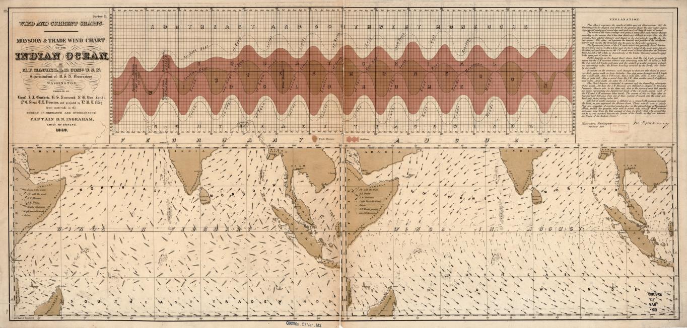
The very predictability of the Monsoons had other effects as well. Those who lived full-time in the major trading ports would know generally when ships would be arriving, from which direction, and the types of goods they would be bringing. Thus, during the northeast monsoon the port of Calicut in southern India, for instance, would receive ships from the east carrying silks from China, spices from the Moluccas (or Spice Islands), musk from Burma, or sandalwood from Bali. When the winds shifted the southwest monsoons would carry ships from the west with gold and ivory from Mozambique, horses from Arabia, and precious metals from the Mediterranean. Once a new group of merchants arrived, they could not immediately trade their goods and return home since they would have to wait for the winds to shift in a more favorable direction. The result was that the port cities of the Indian Ocean were amongst the most cosmopolitan in the world with permanent populations (who were themselves multiethnic) augmented by groups of merchants from a variety of locations who would stay for months at a time. Figure 2.3.1 is a seminal nautical chart created in 1859 by an American naval officer and oceanographer, Matthew Fontaine Maury. This sheet contains 3 different charts. In the upper half of the sheet, there is a note dated January 1860 that states that the chart was created based on data from 16,914 separate observations. The chart shows changes in latitude and monsoon over the course of a year. There are two charts in the lower half of the sheet. The chart on left shows Indian Ocean winds in February during the NE monsoon, while the chart on the right shows Indian Ocean winds in August during the SW monsoon.
The city of Malacca near the tip of the Malaysian Peninsula and facing the island of Sumatra was maybe the greatest example of this cosmopolitanism. Because of its location as one of the major choke points in the Indian Ocean trade, the port was one of the busiest and richest in the entire world. Emerging late in the 14th century as an Islamic sultanate, the city was organized and governed in a way that would be inviting to communities from across the breadth of the Indian Ocean. While there was a central government, the functioning of the city would have been impossible without the efforts of four harbormasters each of whom was responsible for incoming and outgoing ships, collecting duties on merchandise, providing warehouses for the secure storing of goods, and lodging for the new arrivals. The fact that there were four such officials was partly because one individual could not have handled all of those responsibilities for the entire city, but also reflects the multiethnic nature of the incoming merchants and sailors. Malacca was divided into quarters based on the four general regions from which the merchants came and presided over by a harbormaster who also came from that region. So, one quarter took in ships from the Middle East, Persia, India, and Ceylon (Sri Lanka), a second handled local trade from the immediate surroundings of Malacca, another dealt with many of the islands that now make up the nation of Indonesia, and the last was dedicated to ships from Thailand, Burma, Ryukyu, and, most importantly, China. In these quarters newcomers could expect to find foods, houses of worship, and other services that made the city feel comfortable and familiar to them no matter how far from home they were. In another sign of the city’s diversity, Portuguese traveler Tomé Pires, who lived in the city from 1512-1514, counted 84 different languages being spoken on its streets.
One of the fascinating aspects of the 15th-century history of the Indian Ocean is how resistant that history is to discussion through the lens of sovereignty or state power. There were certainly powerful states throughout the region and undoubtedly Ming China cast a wide shadow on the region, but by and large the merchants who plied the Ocean’s waters rarely did so in service to a state. In many cases, trade was carried by groups of merchants connected by family or clan ties. A family based in Aden in southern Arabia, for instance, would settle its members throughout the major ports of the Indian Ocean. These would often be younger men who were expected to pay their dues and raise their status while residing in these faraway ports. Having blood relatives spread throughout the region would ensure that there were representatives living full-time in the key cities who could serve the family’s interests both when their ships were present and after they left. It was also helpful to have trusted relations in a variety of places who could provide the family with valuable contacts and information. Trust was also maintained because only by serving honestly and competently could these ex-pat merchants hope to raise their status and gain more influential positions within the family or clan hierarchy. Even absent direct blood ties, ethnic identity could serve some of the same purposes. Thus, among the larger populations of Persians, Gujaratis, Arabs, and Fujianese (from southern China) were small but very active communities of Jews, Armenians, and Parsis each of whom shared a number of what Kenneth Pomeranz calls “trust-inducing connections,” including a common dialect, a mutual deity, and a shared culture. Records found in the Ben Ezra synagogue in Cairo Egypt, for instance, show that there was frequent communication between the Jewish community there and other Jews as far away as India. The same would likely have been true for Armenian and Parsi communities as well.
We rightly think of our era as a time in which communication and transportation technologies have erased some of the most entrenched geographical boundaries that had once divided the world. Yet, the early-modern Indian Ocean anticipated and, in some ways, surpassed our contemporary connectivity. This was a region in which an East African port like Mogadishu (in modern Somalia) could be ruled by a Somali-speaking Muslim sultan who was conversant in Arabic, with a chief judge from Egypt, and a tax collector who was Persian. Meanwhile, the local merchant community was made up of native East Africans and resident Arabs with East African wives who traded a variety of products from the African interior with Gujarati merchants (from northwest India) who carried spices, cowrie shells, beads, Indian cottons, Southeast Asian spices, and Chinese silks and porcelains. As Kenneth Pomeranz has noted, the Indian Ocean world, “offered a much closer approximation of a borderless world than anything being contemplated today.” (Pomeranz, 33)
- What were some of the ways that the monsoon wind system impacted trade and interaction in the Indian Ocean world?
- Why was the Indian Ocean so significant to the Afro-Eurasian world system?