Humanities LibreTexts

13.3: Geography and the environment

  • Page ID
    67062
  • \( \newcommand{\vecs}[1]{\overset { \scriptstyle \rightharpoonup} {\mathbf{#1}} } \) \( \newcommand{\vecd}[1]{\overset{-\!-\!\rightharpoonup}{\vphantom{a}\smash {#1}}} \)\(\newcommand{\id}{\mathrm{id}}\) \( \newcommand{\Span}{\mathrm{span}}\) \( \newcommand{\kernel}{\mathrm{null}\,}\) \( \newcommand{\range}{\mathrm{range}\,}\) \( \newcommand{\RealPart}{\mathrm{Re}}\) \( \newcommand{\ImaginaryPart}{\mathrm{Im}}\) \( \newcommand{\Argument}{\mathrm{Arg}}\) \( \newcommand{\norm}[1]{\| #1 \|}\) \( \newcommand{\inner}[2]{\langle #1, #2 \rangle}\) \( \newcommand{\Span}{\mathrm{span}}\) \(\newcommand{\id}{\mathrm{id}}\) \( \newcommand{\Span}{\mathrm{span}}\) \( \newcommand{\kernel}{\mathrm{null}\,}\) \( \newcommand{\range}{\mathrm{range}\,}\) \( \newcommand{\RealPart}{\mathrm{Re}}\) \( \newcommand{\ImaginaryPart}{\mathrm{Im}}\) \( \newcommand{\Argument}{\mathrm{Arg}}\) \( \newcommand{\norm}[1]{\| #1 \|}\) \( \newcommand{\inner}[2]{\langle #1, #2 \rangle}\) \( \newcommand{\Span}{\mathrm{span}}\)\(\newcommand{\AA}{\unicode[.8,0]{x212B}}\)

    Geography and the environment

    Mapping American history

    How have prairies, mountains, and rivers defined the United States?

    “America the Beautiful”

    Essay by Dr. Bryan Zygmont

    Katherine Lee Bates was an English professor at Wellesley College in 1893 when she traveled by train to Colorado College to teach a summer course. This form of leisurely travel allowed her the opportunity to see parts of the United States that she had not seen in her first 33 years, most of which had been spent in Massachusetts, the state of her birth. When she finally arrived at the Antler’s Hotel in Colorado Springs, she composed the poem for which she is most famous. It was first published in 1895 as “Pikes Peak,” but in subsequent revisions—first in 1904 and then again in 1911—Bates changed the title to what it is still known by today: American the Beautiful.

    Mississippi watershed, created by Horace Mitchell, Lead Visualizer, NASA Visualization Studio https://svsgsfc.nasa.gov/4493

    Figure \(\PageIndex{1}\): Mississippi watershed, created by Horace Mitchell, Lead Visualizer, NASA Visualization Studio

    Most Americans know the first stanza of this poem, and it is possible that as many are unaware that three additional stanzas exist. The poem is a kind of encomium to the vastness of the United States and to its beauty, both natural and that which was manmade. In the 1911 version, the first stanza concludes with the now-famous line, “From sea to shining sea!” What most Americans might take for granted is how vast from sea to shining sea really is. Indeed, the landmass of the contiguous United States—excluding Alaska and Hawaii—is in excess of 3.1 million square miles. To frame this in another way, the mainland of the United States is roughly equal to that of Western Europe from the Atlantic seaboard to Poland.

    A vast and varied continent

    The vastness of the United States of American has been of continual interest to American painters and photographers. Certainly, if America had anything in excess, it was land. But it is not only the enormity of the United States that artists have commented. They have also made note of the stunning natural beauty of the land, the rise of the urban landscape, and the ways in which the later has, in time, consumed the former. To be sure, an examination of the depiction of the geography and the environment of the United States is an exploration of the history of the United States itself.

    Thomas Moran, Grand Canyon of the Yellowstone, 1872, oil on canvas mounted on aluminum, 213 x 266.3 cm (Smithsonian American Art Museum, Lent by the Department of the Interior Museum, L.1968.84.1)

    Figure \(\PageIndex{2}\): Thomas Moran, Grand Canyon of the Yellowstone, 1872, oil on canvas mounted on aluminum, 213 x 266.3 cm (Smithsonian American Art Museum, Lent by the Department of the Interior Museum, L.1968.84.1)

    We might begin this exploration by examining and comparing two different landscapes: Thomas Moran’s The Grand Canyon of the Yellowstone (1872) and Joseph Stella’s The Voice of the City of New York Interpreted (1920-22). Separated by exactly 50 years, these two paintings might at first seem to be polar opposites. Although the paintings are similar in scale—Stella’s multi-panel Voice of the City measures a majestic 22.5’ x 8.3’ while Moran’s Yellowstone is a not inconsiderable 7’ x 12’—the two artists viewed the land in different ways and with different goals. In the years following the American Civil War, Moran chose to bring attention to the beauty of the American West. In the years following the Great War, Stella aspired to bring attention to the beauty and modernity of the modern American city.

    Thomas Moran stands at the forefront of American landscape painters active during the second half of the nineteenth century, and like Frederic Edwin Church before him, Moran was keenly interested in providing his largely east-coast audience with exciting pictures of the far-off American West. In 1871, the director or the United States Geological Survey, Ferdinand Hayden, invited Moran to join an expedition whose goal was to explore and document the Yellowstone region of what is now Wyoming. Moran was joined by a photographer, William Henry Jackson, and together they visually documented an area that would have seemed almost alien to the people living on the eastern seaboard at the time. Jackson took the photographs, Moran extensively sketched, and those provided the basis for the enormous painting Moran completed in his Washington, D.C. studio the following year.

    Thomas Moran, Grand Canyon of the Yellowstone (detail), 1872, oil on canvas mounted on aluminum, 213 x 266.3 cm (Smithsonian American Art Museum, Lent by the Department of the Interior Museum, L.1968.84.1)

    Figure \(\PageIndex{3}\): Thomas Moran, Grand Canyon of the Yellowstone (detail), 1872, oil on canvas mounted on aluminum, 213 x 266.3 cm (Smithsonian American Art Museum, Lent by the Department of the Interior Museum, L.1968.84.1)

    And what a majestic view Moran provided for his east coast viewers! It is important to note, however, that although the artist has created each individual part with a kind of naturalistic and scientific precision—that is, geological forms and flora are easily identifiable—Moran was not interested in depicting an accurate rending of what Yellowstone looks like from a particular vantage point. Moran’s Yellowstone is at best a kind of composite view of the landscape, and one might suggest the painter was more interested in creating a kind of truth in regards to the experience of viewing Yellowstone than in accurately rendering what it is that he saw while there. Although there is a small human presence—two figures face away from the view on the precipice in the foreground and three others can be seen to their left—this is a composition that is dominated by the resplendent view, a uniquely American nature. Like many of the landscapists who came before him—Thomas Cole, Asher B. Durand, and Church—Moran has imbued the landscape with a spiritual, almost heavenly quality. Clearly, if nature were his religion, one might call Yellowstone Moran’s cathedral.

    Long-lasting effects

    Little did Moran know the long-lasting effect his participation in Hayden’s expedition would have. At the conclusion of this adventure, Hayden submitted his document, Preliminary Report on the United States Geological Survey of Montana and Portions of Adjacent Territories; Being a Fifth Annual Report of Progress, to the United States Congress. He augmented his report with Jackson’s magnificent photography and Moran’s sketches and paintings that visually that captured what Hayden’s words could not. Hayden’s plan was a success. Yellowstone became the first National Park on 1 March 1872 when President Ulysses S. Grant signed into the law “An Act to set apart a certain Tract of Land lying near the Head-waters of the Yellowstone River as a public Park.”

    If Moran’s painting shows an American monument from the natural world, then, Joseph Stella’s colossal The Voice of the City of New York Interpreted (1920-22) depicts a man-made monument to America. And like Moran’s earlier work, there is a both an implicit and explicitly spiritual quality to Stella’s visual encomium to New York City, his adoptive home. Joseph Stella was born in Muro Lucano Italy, southeast of Naples. He emigrated to New York City in 1896 at the age of 18 and shortly thereafter abandoned his previous aspiration to study medicine and instead attended the Art Students League, studying under William Merritt Chase. Stella returned to Italy in 1909 and over the next four years—that is, until his return to New York City in 1913—he saw and absorbed the Modernist styles then flourishing across Europe. The year of his return coincided with the Armory Show, the now famous exhibition in New York City that introduced America to the modernist art Stella had seen while in Italy and France.

    Joseph Stella, The Voice of the City of New York Interpreted, 1920-22, oil and tempera on canvas (five panels), 99.75 x 270 inches overall (Purchase 1937 Felix Fuld Bequest Fund 37.288a-e, Newark Museum of Art)

    Figure \(\PageIndex{4}\): Joseph Stella, The Voice of the City of New York Interpreted, 1920-22, oil and tempera on canvas (five panels), 99.75 x 270 inches overall (Purchase 1937 Felix Fuld Bequest Fund 37.288a-e, Newark Museum of Art)

    The paintings Stella completed after his return show the strong influence of the Italian Futurists he saw in Europe, and New York Interpreted is very much his magnum opus in this vein. The horizontal, multi-panel composition has the form of a Renaissance altarpiece—van Eyck’s masterpiece, the Ghent Altarpiece comes to mind—and this gives Stella’s painting a slight whisper of religious reverence. However, whereas the early Renaissance Flemish master painted a religious scene with a profound sense of naturalistic precision, Stella has instead shown a modern, industrial, and manmade scene while embracing an abstraction that only reveals the underlying architectural forms after some concerted effort by the viewer. Jesus and Mary have been replaced by skyscrapers and bridges.

    Confusion of light and sounds

    Although this polyptych does not necessarily contain a narrative, it is natural that the viewer observe it from left to right. The leftmost panel shows the Port of New York by night. The strong geometric lines that crisscross the panel provide a sense of power and energy to the composition, but the desaturated and muted blues of the nighttime sky tempers the view. During the day this would be bursting with human activity, a vibrancy that has left with the setting sun. That vibrancy is clearly to be found in the second panel, commonly called The White Way. This is a view of Broadway, which, by the 1920s, was an area filled with energy, verve, and human bustle. The muted colors of the first panel have been replaced with charged reds, high-energy oranges, and loaded yellows. The diagonal lines lead us into the deep spaces of the composition to reveal an almost heavenly depiction of the electric lights for which Broadway was—and still is—so famous. The curvilinear lines and the breathtaking use of color visually render the panoply of sounds that surround Manhattan. When writing of this panel, Stella explained, “Here are sensations produced by the confusion of light and sounds as one emerges from subterranean passages to the street above.” Indeed, the artist seemingly provides a view of the city from multiple perspectives: from below, from above, and from a distance.

    Joseph Stella, The Voice of the City of New York Interpreted (detail), 1920-22, oil and tempera on canvas (five panels), 99.75 x 270 inches overall (Purchase 1937 Felix Fuld Bequest Fund 37.288a-e, Newark Museum of Art)

    Figure \(\PageIndex{5}\): Joseph Stella, The Voice of the City of New York Interpreted (detail of the The White Way), 1920-22, oil and tempera on canvas (five panels), 99.75 x 270 inches overall (Purchase 1937 Felix Fuld Bequest Fund 37.288a-e, Newark Museum of Art)

    If the central panel of the Ghent Altarpiece depicts an enthroned God the Father, then the central panel of this secular polyptych contains the deity of early-twentieth-century urban life: that of the towering skyscraper. The 22-story Flatiron Building (1902) is easily recognizable in the lower center, and yet it is dwarfed by the soaring architecture framed behind it. The shape of the Flatiron building resembles the prow of a ship, and with this as a context, we are either moving towards it, or this mass of industry and technology is moving towards us as viewers. The buildings themselves are not just tall, they serve as reminders as to the technological advances of the twentieth century. We see smokestacks and gas towers, necessary beacons of modern urban life.

    The fourth panel mirrors the second; it shows a depiction of Broadway. The color palette within this panel is bright and vibrant; pops of red, blue, yellow, and green draw the attention of our eyes, and descending vertical lines clearly contain musical notes. These small visual references reiterate the idea that the city is alive with the sound of music. Like the other panels, architectural structure is present. Just above the lowermost register we can see a number of small circles that Stella has filled with a kaleidoscopic mix of colors. These appear as whispered references to the stained-glass rose windows so prevalent in gothic cathedrals.

    But if the color-filled circles in the fourth panel softly speak to medieval churches, then the pair of lancet arches in the fifth and final panel do not whisper “religion,” they wail it. The structure that it represents is one that is recognizable to every New Yorker; it is the Brooklyn Bridge. First opened in 1883, this connection crossing the East River was in 1920—and remains so today—one of defining architectural structures of The City That Never Sleeps. But if Notre Dame is a monument to God in glass and stone, then the Brooklyn Bridge is a monument to modernity, engineering, and life in steel.

    Joseph Stella, The Voice of the City of New York Interpreted (detail), 1920-22, oil and tempera on canvas (five panels), 99.75 x 270 inches overall (Purchase 1937 Felix Fuld Bequest Fund 37.288a-e, Newark Museum), a Seeing America video

    Figure \(\PageIndex{6}\): Joseph Stella, The Voice of the City of New York Interpreted (detail of Brooklyn Bridge), 1920-22, oil and tempera on canvas (five panels), 99.75 x 270 inches overall (Purchase 1937 Felix Fuld Bequest Fund 37.288a-e, Newark Museum), a Seeing America video

    When viewed as a whole, The Voice of the City of New York Interpreted eloquently speaks to Stella’s belief that there was something religious—something divine, sacred, and transcendent—about the vibrancy and vitality of the modern American city. And in the same vein, The Grand Canyon of the Yellowstone similarly testifies to the Moran’s belief that there was something religious—divine, sacred, and transcendent—about the beauty of the American landscape. In this way, these two paintings—one nearly photographic in its scientific precision and the second, an excellent example of twentieth-century abstraction—have much in common, but they also indicate the shift that occurred in the United States when it became an industrialized and modern nation.

    Suburban desert

    If Moran painted nature in Yellowstone and if Stella painted the city in New York Interpreted, then in Fenetre, Eastlake Greens, San Diego (2001), Stéphane Couturier shows the abrupt collision between the two. At first glance, the color palette might suggest that Couturier’s work is a painting, but it is instead a stunningly exposed photograph. Yet despite the photographic medium, the artist has utilized a painterly framing device. Utilizing an open window as an internal frame for a landscape or portrait has a long tradition in Western art. Gabriel Mesu’s A Woman Seated at a Window and Henri Matisse’s Open Window, Collioure, are excellent examples of the open window as a framing mechanism.

    Stéphane Couturier, Fenetre, Eastlake Greens, San Diego, edition 4/8, 2001, dye coupler print, 130.81 x 107.95 x 2.54 cm (Los Angeles County Museum of Art, © Stéphane Couturier)

    Figure \(\PageIndex{7}\): Stéphane Couturier, Fenetre, Eastlake Greens, San Diego, edition 4/8, 2001, dye coupler print, 130.81 x 107.95 x 2.54 cm (Los Angeles County Museum of Art, © Stéphane Couturier)

    But the window in Couturier’s photograph is different, it makes clear that the space the viewer stands within is the second story of an unfinished building. The vista we have is likewise different. Rather than look out at a balcony, some potted plants and several sailboats in a harbor as we do in Matisse’s masterpiece, here lumber and plywood frame homes in various state of completion, and further back, an austere landscape on the outskirts of San Diego.

    The homes closest to us—those visible through and just above the exposed floor upon which we stand—appear to be completed and occupied. The yards have been landscaped, cars park in the driveway, some shutters have been opened while others remain closed, and families are, no doubt, present. Just beyond those three homes are many others structures that are clearly not yet finished. Pickup trucks belonging to construction workers line the streets, still-wrapped shingles rest atop unfinished roofs, scaffolding can be seen, and office trailers provide respite from the unrelenting San Diego sun.

    Stéphane Couturier, Fenetre, Eastlake Greens, San Diego (detail), edition 4/8, 2001, dye coupler print, 130.81 x 107.95 x 2.54 cm (Los Angeles County Museum of Art, © Stéphane Couturier)

    Figure \(\PageIndex{8}\): Stéphane Couturier, Fenetre, Eastlake Greens, San Diego (detail), edition 4/8, 2001, dye coupler print, 130.81 x 107.95 x 2.54 cm (Los Angeles County Museum of Art, © Stéphane Couturier)

    To view the photograph from the bottom to the top, then, we can see a progression from the homes that have been completed to those which eventually will be. But beyond those homes under construction, we can see the seemingly endless landscape that surrounds San Diego. If we were to reference what is perhaps the most famous landscape in the history of American art—Thomas Cole’s 1833 painting The Oxbow—we might gain further insight as to Couturier’s goals and intentions in Fenetre, Eastlake Greens, San Diego. In The Oxbow, humankind has cultivated and tamed the right (eastern) side of the painting; homes have been built, fields have been cleared, farms have been planted. The untamed wilderness remains on the western (left) side of the painting, but there is a sense of the inevitability of the human movement westward. Manifest Destiny is underway. This same sense of certainty is evident in Couturier’s photograph. Although there is a proverbially line in the sand—a junction where the buildings end and the landscape starts — we know this line is temporary. A view out of this same window today would show many more homes and less open land.

    That line in the sand has been in constant flux since the arrival of Europeans in North America centuries ago. As the nineteenth century progressed, artists took particular interest in painting the vastness and beauty of this continent. The works these artists completed showed the American landscape with a kind of religious reverence. In the transition from the nineteenth to the twentieth century, people found themselves moving from the rural American farmland to increasingly modern urban centers. With this shift, artists then turned their attention to the bursting cities; bright, noisy, and energetic. They were also ever growing, and as the twentieth century grew into the twenty-first, the land that had once seemed endless, was rapidly consumed by the sprawl of humanity. Manifest Destiny had been achieved. The frontier had closed.

    c. 1070
    The Great Serpent Mound

    Many interpretations have been proposed for this mound in modern-day Ohio—examine the clues and see what you think.

    The Great Serpent Mound

    Uncoiling the cosmology of ancient America

    by

    Fort Ancient Culture(?), Great Serpent Mound, c. 1070, Adams County, Ohio (photo: Eric Ewing, CC BY-SA 3.0)

    Figure \(\PageIndex{9}\): Fort Ancient Culture(?), Great Serpent Mound, c. 1070, Adams County, Ohio (photo: Eric Ewing, CC BY-SA 3.0)

    A serpent 1300 feet long

    The Great Serpent Mound in rural, southwestern Ohio is the largest serpent effigy in the world. Numerous mounds were made by the ancient Native American cultures that flourished along the fertile valleys of the Mississippi, Ohio, Illinois, and Missouri Rivers a thousand years ago, though many were destroyed as farms spread across this region during the modern era. They invite us to contemplate the rich spiritual beliefs of the ancient Native American cultures that created them.

    The Great Serpent Mound measures approximately 1,300 feet in length and ranges from one to three feet in height. The complex mound is both architectural and sculptural and was erected by settled peoples who cultivated maize, beans and squash and who maintained a stratified society with an organized labor force, but left no written records. Let’s take a look at both aerial and close-up views that can help us understand the mound in relationship to its site and the possible intentions of its makers.

    Ephraim George Squier and E. H. Davis, "The Serpent;" entry 1014, Adams County Ohio. Pl. XXXV, Ancient monuments of the Mississippi Valley: comprising the results of extensive original surveys and explorations, Washington: Smithsonian institution, 1848

    Figure \(\PageIndex{10}\): Ephraim George Squier and E. H. Davis, “The Serpent;” entry 1014, Adams County Ohio. Pl. XXXV, Ancient monuments of the Mississippi Valley: comprising the results of extensive original surveys and explorations, Washington: Smithsonian institution, 1848

    Supernatural powers?

    ​ The serpent is slightly crescent-shaped and oriented such that the head is at the east and the tail at the west, with seven winding coils in between. The shape of the head perhaps invites the most speculation. Whereas some scholars read the oval shape as an enlarged eye, others see a hollow egg or even a frog about to be swallowed by wide, open jaws. But perhaps that lower jaw is an indication of appendages, such as small arms that might imply the creature is a lizard rather than a snake. Many native cultures in both North and Central America attributed supernatural powers to snakes or reptiles and included them in their spiritual practices. The native peoples of the Middle Ohio Valley in particular frequently created snake-shapes out of copper sheets.

    Aerial view of the Great Serpent Mound, c. 1070, Adams County, Ohio

    Figure \(\PageIndex{11}\): Aerial view of the Great Serpent Mound, c. 1070, Adams County, Ohio

    The mound conforms to the natural topography of the site, which is a high plateau overlooking Ohio Brush Creek. In fact, the head of the creature approaches a steep, natural cliff above the creek. The unique geologic formations suggest that a meteor struck the site approximately 250-300 million years ago, causing folded bedrock underneath the mound.

    Celestial hypotheses

    Aspects of both the zoomorphic form and the unusual site have associations with astronomy worthy of our consideration. The head of the serpent aligns with the summer solstice sunset, and the tail points to the winter solstice sunrise. Could this mound have been used to mark time or seasons, perhaps indicating when to plant or harvest? Likewise, it has been suggested that the curves in the body of the snake parallel lunar phases, or alternatively align with the two solstices and two equinoxes.

    View of tail, Fort Ancient Culture(?), Great Serpent Mound, c. 1070, Adams County, Ohio (photo: The Last Cookie, CC BY 2.0)

    Figure \(\PageIndex{12}\): View of tail, Fort Ancient Culture(?), Great Serpent Mound, c. 1070, Adams County, Ohio (photo: The Last Cookie, CC BY 2.0)

    Some have interpreted the egg or eye shape at the head to be a representation of the sun. Perhaps even the swallowing of the sun shape could document a solar eclipse. Another theory is that the shape of the serpent imitates the constellation Draco, with the Pole Star matching the placement of the first curve in the snake’s torso from the head. An alignment with the Pole Star may indicate that the mound was used to determine true north and thus served as a kind of compass.

    Of note also is the fact that Halley’s Comet appeared in 1066, although the tail of the comet is characteristically straight rather than curved. Perhaps the mound served in part to mark this astronomical event or a similar phenomenon, such as light from a supernova. In a more comprehensive view, the serpent mount may represent a conglomerate of all celestial knowledge known by these native peoples in a single image.

    Who built it?

    Determining exactly which culture designed and built the effigy mound, and when, is a matter of ongoing inquiry. A broad answer may lie in viewing the work as being designed, built, and/or refurbished over an extended period of time by several indigenous groups. The leading theory is that the Fort Ancient Culture (1000-1650 C.E.) is principally responsible for the mound, having erected it in c. 1070 C.E. This mound-building society lived in the Ohio Valley and was influenced by the contemporary Mississippian culture (700-1550), whose urban center was located at Cahokia in Illinois. The rattlesnake was a common theme among the Mississippian culture, and thus it is possible that the Fort Ancient Culture appropriated this symbol from them (although there is no clear reference to a rattle to identify the species as such).

    View of the Great Serpent Mound, 1070(?), Adams County, Ohio (photo: Katherine T. Brown)

    Figure \(\PageIndex{13}\): View of the Great Serpent Mound, 1070(?), Adams County, Ohio (photo: Katherine T. Brown)

    An alternative theory is that the Fort Ancient Culture refurbished the site c. 1070, reworking a preexisting mound built by the Adena Culture (c.1100 B.C.E.-200 C.E.) and/or the Hopewell Culture (c. 100 B.C.E.-550 C.E.). Whether the site was built by the Fort Ancient peoples, or by the earlier Adena or Hopewell Cultures, the mound is atypical. The mound contains no artifacts, and both the Fort Ancient and Adena groups typically buried objects inside their mounds. Although there are no graves found inside the Great Serpent Mound, there are burials found nearby, but none of them are the kinds of burials typical for the Fort Ancient culture and are more closely associated with Adena burial practices. Archaeological evidence does not support a burial purpose for the Great Serpent Mound.

    Debate continues

    Whether this impressive monument was used as a way to mark time, document a celestial event, act as a compass, serve as a guide to astrological patterns, or provide a place of worship to a supernatural snake god or goddess, we may never know with certainty. One scholar has recently suggested that the mound was a platform or base for totems or other architectural structures that are no longer extant, perhaps removed by subsequent cultures. All to say, scholarly debate continues, based on on-going archaeological evidence and geological research. But without a doubt, the mound is singular and significant in its ability to provide tangible insights into the cosmology and rituals of the ancient Americas.

    Go deeper

    Great Serpent Mound at The Metropolitan Museum of Art’s Timeline of Art History

    Serpent Mound at the Ohio Historical Society

    1821
    Clean water for a young Philadelphia

    Top American bucket list destination in 1821

    Clean water for a young Philadelphia

    Making nature useful, the Fairmount Water Works

    by and

    Video \(\PageIndex{1}\): Thomas Birch, Fairmount Water Works, 1821, oil on canvas, 51.1 x 76.3 cm (Pennsylvania Academy of the Fine Arts), a Seeing America video. Speakers: Dr. Anna O. Marley, Curator of Historical American Art, Pennsylvania Academy of the Fine Arts and Dr. Steven Zucker

    Test your knowledge with a quiz

    Key points

    • As Philadelphia grew, so did the need to secure clean sources of water. When it opened in 1815, the Fairmount Water Works was celebrated as an example of American ingenuity, harnessing the power of nature to create and support a modern, healthy, beautiful city.
    • Built in a Neoclassical style to evoke the grandeur and moral well-being associated with classical antiquity, the Fairmount Water Works was the most popular tourist destination in America until the 1840s. Prints and decorative objects featuring the Water Works were manufactured and circulated internationally, making it an iconic image widely associated with the early American republic.
    • Along with the Water Works, the Schuylkill canal made the river more navigable through a series of dams and locks. This was part of a series of canals, constructed in the early 19th century, that enabled trade and expansion within the interior of the United States.

    More to think about

    The video states that the Water Works were the number one tourist destination in the United States until supplanted by Niagara Falls. Are there tourist destinations in your area that are linked to technology? How would you compare them to the Water Works in function and appearance?

    1867
    Business, art, and the American West

    Business or pleasure? Watkins could photograph both beautifully.

    Business, art, and the American West

    Early photographs by Carlton Watkins

    by and

    Video \(\PageIndex{2}\): Carleton E. Watkins, Eagle Creek, Columbia River, 1867, albumen silver print, 40.01 × 52.39 cm (LACMA). Speakers: Elizabeth Gerber, LACMA and Dr. Beth Harris

    Test your knowledge with a quiz

    Key points

    • As industry and tourism expanded westward, photography became an important documentary tool for strategic planning and advertising, particularly for people who remained in the eastern United States. With the Transcontinental Railroad nearly complete, planning had begun on northern and southern routes across the country, and photographs like Eagle Creek, Columbia River were important for understanding the local geography and possible business opportunities. They also stoked popular imagination about the western territories.
    • To capture the expansive terrain of the wilderness and also preserve precise detail, Carleton Watkins invented the mammoth camera, which recorded images on large glass plates. This process yielded crisp, clear photographs, but also required the photographer to navigate the countryside while carrying delicate and heavy equipment.
    • This image was commissioned by the Oregon Steam Navigation Company to inform their business decisions, but Carleton Watkins made similar photographs that would be sold to the general public in galleries. Still, photography was not widely considered fine art until the early decades of the twentieth century.

    More to think about

    This photograph was commissioned by the Oregon Steam Navigation Company to inform their planned work along the Columbia River. Using one of the high resolution images available, look at the types of information that Carleton Watkins is careful to include in this one picture. How do you think these details might have been used by the company? What do we learn about this region?

    1869
    A breath of fresh air, NYC's Central Park

    To bring “polite sociability” to the city, designers blended nature’s greatest hits into one ambitious park.

    A breath of fresh air, NYC’s Central Park

    This iconic park set the standard for public spaces

    by

    Aerial view of Central Park, New York City (photo: © Ester Inbar)

    Figure \(\PageIndex{14}\): Aerial view of Central Park, New York City (photo: © Ester Inbar)

    In the center of Manhattan Island lies a great expanse of sculpted nature. This large swath of greenery—Central Park—was the first great manifesto of a new urban vision that sought to introduce nature into the heart of commercial and industrial cities in the United States. As a measure of its tremendous success, the park quickly and enduringly became one of the most popular public attractions in New York City and an icon of a metropolis often famed more for its commercial power than for its art.

    Nature and the city

    A design of the magnitude and distinction of Central Park is necessarily the product of a fortuitous set of historical conditions. First, and broadly speaking, the park is an expression of the American fascination with the natural landscape that had defined the national character since colonial times. Although it was widely recognized that commercial cities had always been necessary, nineteenth-century American art, literature, politics, and popular culture all celebrated rural land as a central element of the nation’s “exceptionalism.” Henry David Thoreau, whose book Walden (1854) chronicled his retreat for self-renewal in rural Massachusetts, suggested every American city should be obliged to set aside land for a “primitive forest” in order to “preserve all the advantages of living in the country.”

    View of Central Park, New York City (photo: alan-light, CC BY 2.0)

    Figure \(\PageIndex{15}\): View of Central Park, New York City (photo: alan-light, CC BY 2.0)

    The second crucial factor, by the middle of the nineteenth century, was the widespread awareness that industrial cities needed to be carefully planned. Reformers such as the poet and newspaper editor William Cullen Bryant and the travel writer, horticulturalist, and co-designer of Central Park, Frederick Law Olmsted embraced the urban future, but they wanted to better the lives of all city dwellers by introducing nature as an antidote to what they saw as the unsafe and unsanitary qualities of large cities. Of course, these reformers knew that true rustic nature was impossible in the middle of cities. Instead, they sought to cultivate a man-made, pastoral landscape that captured the best qualities of nature as filtered through human invention and design. Large parks were to be “the lungs of the city.” The reformers professed a Romantic conviction that being surrounded by nature assuaged the nerves and mind and helped “unbend” certain physical and psychological tensions.

    View of a grove with schist outcropping, Central Park, New York City (photo: kpaulus, CC BY 2.0)

    Figure \(\PageIndex{16}\): View of a grove with schist outcropping, Central Park, New York City (photo: kpaulus, CC BY 2.0)

    Some reformers, though, expressed their views in a more paternalistic manner, showing disdain toward the poor and working classes. They argued that Central Park’s bucolic scenery should serve as a setting to refine the coarse, impolite manners thought to characterize especially the new, often impoverished immigrants then found in large cities like New York. Olmsted himself wrote that “a large part of the people of New York are ignorant” of a park’s social purpose and needed “to be trained in the proper use of it.” Olmsted’s original objective was to direct visitors to stroll through Central Park and quietly admire the natural scenery; they were not to partake, as they often do today, in strenuous exercise, large festivals or concerts, or any other behavior that would disturb the park’s bucolic ambience. Early on, he and his design partner Calvert Vaux issued regulations to achieve the desired behavior among park visitors: a polite sociability that might then filter out into behavior in the city itself.

    The English landscape

    View of sheltered valley, Leonardslee Gardens, England (photo: ukgardenphotos, CC BY-NC-ND 2.0)

    Figure \(\PageIndex{17}\): View of sheltered valley, Leonardslee Gardens, England (photo: ukgardenphotos, CC BY-NC-ND 2.0)

    These social concerns relied on the aesthetics of the natural landscape pioneered earlier in England. The “English landscape gardens” of the eighteenth century, as well as the early nineteenth-century suburban cemeteries of Paris, especially Père-Lachaise, strongly influenced landscape design in the United States. In the 1830s, for example, the Rural Cemetery Movement produced important landscape designs including Mount Auburn in Cambridge, Massachusetts, Green-Wood in Brooklyn (below), and Laurel Hill in Philadelphia. These suburban cemeteries were intended to provide a quiet retreat and confer physical and mental health benefits on visitors. They were designed according to the aesthetics of the English landscape garden (above), in which winding paths, open meadows, ponds, and occasional architectural “follies” created picturesque effects very different from the rigidly symmetrical or geometrical layouts of gardens in the Italian and French traditions, such as the Boboli Gardens in Florence or the royal gardens at Versailles.

    Green-Wood Cemetery, Brooklyn, 1836 (photo: Dave Bledsoe, CC: BY-NC-SA 2.0)

    Figure \(\PageIndex{18}\): Green-Wood Cemetery, Brooklyn, 1836 (photo: Dave Bledsoe, CC: BY-NC-SA 2.0)

    Politics and Central Park

    Political support was the third major factor in Central Park’s development. The land acquired for the park had been included in the city’s gridded urban plan of 1811, which was an early effort to take control of Manhattan Island’s development. The area was treeless, rocky terrain. On the west side it encompassed a small settlement that counted 264 residents in the 1855 census. About half of the modest houses in “Seneca Village,” as it was known, were owned by free African Americans, along with many German and Irish immigrants. There were at least two churches, cemeteries, and a school. City and state government used the legal power of eminent domain to claim the land as part of Central Park, forcibly evicting all the residents by 1857.

    Frederick Law Olmstead, plan, 1869 (larger image available)

    Figure \(\PageIndex{19}\): Frederick Law Olmsted, plan, 1869 (larger image available)

    New York engineer Egbert Viele—who was responsible for the first, unbuilt plan for Central Park in 1856—described the land as a “pestilential spot” with “miasmatic odors” emanating from the untended ground. Unhealthy and unsightly, the land was ripe for reform as projections for Manhattan’s future growth pushed the boundary of built-up land further and further north. Reformers and politicians also soon realized that the 1811 plan had not sufficiently taken account of the need for recreational and other types of open space. Even the few parks provided by that plan had mostly been built over in the intervening decades as real estate interests trumped the public good.

    In 1853, after more than a decade of agitation by Bryant, landscape architect Andrew Jackson Downing, and others, the state of New York authorized the creation of a large park in Manhattan, originally to be built and designed by Viele. However, his design was considered perfunctory, offering little in the way of artistry or ingenuity. The Central Park Commissioners, as the governmental body was known, appointed Frederick Law Olmsted as superintendent of works and called for an open competition for a new design.

    Olmsted was not a designer or engineer. He had been a farmer and horticultural enthusiast on Staten Island for several years before traveling in northern Europe, Mexico, and elsewhere. His travels inspired him to take up writing and, later, magazine publishing. Calvert Vaux approached Olmsted about jointly submitting a design to the park competition. Vaux, an English architect, had earlier worked in partnership with Downing and eagerly took up the latter’s Romantic ideas about landscape. His partnership with Olmsted resulted in a pairing of like-minded, strong-willed individuals determined to mold the park to their shared vision.

    Calvert Vaux, Gothic Bridge, Central Park, New York City (photo: Bryan Schorn, CC BY-SA 3.0)

    Figure \(\PageIndex{20}\): Calvert Vaux, Gothic Bridge, Central Park, New York City (photo: Bryan Schorn, CC BY-SA 3.0)

    The plan

    Olmsted and Vaux won the design competition with their “Greensward Plan,” the last of thirty-two to be submitted. Two elements distinguished the Greensward design from those of their competitors. One was the sheer allure of their landscape features, conveyed in twelve before-and-after panels included in their submission. The other was the ingenious separation of pedestrian and cross-park carriage (now vehicular) traffic.

    65th Street transverse in red (detail), Frederick Law Olmstead, Central Park Plan, 1869

    Figure \(\PageIndex{21}\): 65th Street transverse in red (detail), Frederick Law Olmsted, Central Park Plan, 1869

    The competition brief had insisted that four roadways should connect the east and west sides of Manhattan through the park. All other submissions put those roads on the ground surface, effectively dividing the park into five zones separated by street traffic. However, Olmsted and Vaux submerged their “transverse” roads below ground level and created a continuous expanse of park differentiated by designed topography. As they discovered during construction, this critical invention gave them the chance to increase the park’s picturesque scenery since the many drives and walking paths that cross over the transverses and bridal paths could be embellished by attractive bridges.

    Sheep Meadow, Central Park, New York City (photo: yourdon, CC BY-NC-SA 2.0)

    Figure \(\PageIndex{22}\): Sheep Meadow, Central Park, New York City (photo: yourdon, CC BY-NC-SA 2.0)

    From south to north, the park is laid out to create distinct visual experiences, helping the visitor navigate the vast space and creating picturesque variety in strong contrast to the rectilinearity of the gridded city around it. South of the reservoirs—there were originally three but today only the largest irregular one remains as a lake—the park is a series of pastoral areas, including the large glade called the Parade Ground (now the Sheep Meadow) surrounded by copses or small groves of trees (above).

    The Mall, Central Park, New York City (photo: chrisschoenbohm, CC BY-NC 2.0)

    Figure \(\PageIndex{23}\): The Mall, Central Park, New York City (photo: chrisschoenbohm, CC BY-NC 2.0)

    In the southern end of the park, we find one area that departs from the naturalism: the long, tree- and bench-lined Promenade now know as the Mall (above) which leads to the Terrace and Bethesda Fountain (below).

    Major and Knapp Engraving, Manufacturing, and Lithographic Company, The Terrace, 1869, color lithograph

    Figure \(\PageIndex{24}\): Major and Knapp Engraving, Manufacturing, and Lithographic Company, The Terrace, 1869, color lithograph

    Emma Stebbins, Angel of Waters, 1873, bronze, Bethesda Fountain (photo: Wayne Noffsinger, CC: BY 2.0)

    Figure \(\PageIndex{25}\): Emma Stebbins, Angel of Waters, 1873, bronze, Bethesda Fountain (photo: Wayne Noffsinger, CC BY 2.0)

    The Terrace is divided into upper and lower sections, a remarkably classical environment with wide, symmetrical stairs and a sense of formality. Jacob Wrey Mould, an English architect who worked on the park for Olmsted and Vaux until 1874, designed its ornament. A surprising and elegant space, the Terrace is a delightful foil to the landscape around it. At its center is the much-photographed fountain surmounted by sculptor Emma Stubbins’ Angel of the Waters, installed in 1873 (left). Between the Terrace steps is the Arcade, a long subterranean space with a stunning ceiling decorated with tiles designed by Mould and manufactured by the Minton Tile Works in England. The formal but festive appearance of the Terrace is appropriate for a space conceived as the city’s “open air hall of reception.”

    North of the Lake is the Ramble, a series of small, twisting paths along rocky outcroppings of the local stone, called schist, that can be seen throughout the park. At the northernmost edge of the park is the most rugged landscape with the densest foliage, then and now the park’s least visited section. But the area offers some of the park’s most stunning features, including the Ravine with its small brook, waterfalls, and tomb-like Glen Span Arch, made from massive, rough-faced stones. The quiet of the area is an almost haunting experience; it feels much more secluded than its actual distance from the busy surrounding streets would suggest.

    Glen Span Arch, Central Park, New York City (photo: gigi_nyc, CC BY-NC-ND 2.0)

    Figure \(\PageIndex{26}\): Glen Span Arch, Central Park, New York City (photo: gigi_nyc, CC BY-NC-ND 2.0)

    The park’s influence

    Central Park was very much a product of its particular moment in time, a combination of aesthetic ideas, urban concerns, and political will that coalesced in the decade before the Civil War. Its instant success led to other opportunities for Olmsted and Vaux to apply their approach to landscape design: a few of the important projects were Prospect Park in Brooklyn (1866-73), the Buffalo park system (begun 1868), and the suburb of Riverside, Illinois (1868).

    Later, working apart from Vaux, Olmsted had a flourishing practice: he designed the campus of Stanford University (1889), the Druid Hills district in Atlanta (1892), and the grounds of the World’s Columbian Exposition in Chicago (1893)—just three among many projects. The landscape philosophy developed by Olmsted and Vaux and first expressed at Central Park had lasting influence, inspiring, for instance, Jens Jensen’s “prairie landscapes” in Chicago and elsewhere in the early twentieth century. It was arguably no exaggeration when Harper’s Magazine declared in 1862 that Central Park was “the finest work of art ever executed in this country.” It may still be.

    Essay by Paul A. Ranogajec

    Go deeper

    The Central Park website

    Industrialization and Conflict in America, 1840-70, on The Metropolitan Museum of Art’s Heilbrunn Timeline of Art History

    Morrison H. Heckscher, Creating Central Park (New York: Metropolitan Museum of Art, 2008).

    Francis R. Kowsky, Country, Park & City: The Architecture and Life of Calvert Vaux (New York: Oxford University Press, 2003).

    Roy Rosenzweig and Elizabeth Blackmar, The Park and the People: A History of Central Park (Ithaca, NY: Cornell University Press, 1992).

    David Schuyler, The New Urban Landscape: The Redefinition of City Form in Nineteenth-Century America (Baltimore: Johns Hopkins University Press, 1986).

    Robert Twombly, ed. Frederick Law Olmsted: Essential Texts (New York: W. W. Norton, 2010).

    1872
    The painting that inspired a National Park

    Painting, photography, and the railroad come together to preserve a topography unique in the world

    The painting that inspired a National Park

    Awe and grandeur in the service of an expanding United States

    by and

    Video \(\PageIndex{3}\): Thomas Moran, Grand Canyon of the Yellowstone, 1872, oil on canvas mounted on aluminum, 213 x 266.3 cm (Smithsonian American Art Museum, lent by the Department of the Interior Museum, L.1968.84.1). Speakers: Dr. Eleanor Jones Harvey and Dr. Beth Harris.

    Test your knowledge with a quiz

    Key points

    • In the 19th century, Americans living in the eastern United States had little access to the western territories. When Ferdinand Hayden led the first geological survey of Yellowstone in 1871, he brought along a photographer, William Henry Jackson, and a painter, Thomas Moran, to document the area. Their images helped influence Congress to make Yellowstone the first National Park and this painting was purchased to celebrate that legislation.
    • After the Transcontinental Railroad was completed in 1869, railroad companies sought to expand throughout the west and encouraged travelers to visit the region. Moran’s images of Yellowstone helped transform the area known as “Colter’s Hell” to a tourist destination considered a “wonderland.” Although Grand Canyon of the Yellowstone is actually a composite of different locations, the precise geological and biological details make this painting feel authentic.
    • Part of the myth of the American West was that these were untouched lands, erasing the local Native Americans who often assisted explorers, as we see in this painting. Around Yellowstone, these tribes were forced onto reservations when gold was discovered in the region two years later, contributing to the larger Plains Indian wars that had intensified after the Civil War.
    • Moran painted another version of Grand Canyon of the Yellowstone for the World’s Columbian Exposition in 1893, where Frederick Jackson Turner argued his “frontier thesis.” He characterized American expansion as a civilizing force across the continent.

    More to think about

    Thomas Moran’s paintings of Yellowstone were very popular with the viewing public and part of a successful tourism campaign. Today, professional and amateur photographs document and share images of iconic locations. Find an example from a familiar landmark or site and look at how it is framed, composed, or filtered. Does this modern image share any similarities with how Moran portrayed Yellowstone?

    During the 1871 expedition, William Henry Jackson and Thomas Moran worked side-by-side and frequently collaborated. Compare some of the photographs taken by Jackson with Moran’s paintings. Why do you think Ferdinand Hayden brought both a photographer and a painter on his survey of Yellowstone?

    c. 1874-80
    The battle for National Parks

    Captured here in paint, this grand Californian landscape would soon disappear under water.

    The battle for National Parks

    This grand Californian landscape would soon disappear under water

    by and

    Video \(\PageIndex{4}\): Albert Bierstadt, Hetch Hetchy Valley, California, c. 1874-80, oil on canvas, 94.8 x 148.2 cm (Bequest of Laura M. Lyman, in memory of her husband Theodore Lyman, Wadsworth Atheneum Museum of Art). Speakers: Erin Monroe, Wadsworth Atheneum Museum of Art and Dr. Beth Harris

    Test your knowledge with a quiz

    Native peoples of the Plains knew the lands west of the Mississippi as their homelands, and were connected to the landscape by ancestral ties, and by sacred stories about their origins. The lands and wildlife of the West were inter- woven with their daily lives and belief systems. For Eastern Americans, on the other hand, the West was a powerful abstraction remote from their everyday experience, a vast region where dreams of a better life of wealth and opportunity might find fulfillment. From the sixteenth to the nineteenth century, the European encounter with the West was shaped by such imaginings.

    John Cawelti has identified four distinct versions of the frontier myth. For some, the new trans-Mississippi frontier West reinvigorated the dreams of gold and newfound wealth that had, since the beginning, drawn Europeans to what they perceived as the New World. For others, the West offered opportunities to renew and reform a corrupt society—motivations similar to those of the seventeenth-century Protestants who migrated to New England. The West also signified escape from the burdens of a restrictive social order: unstructured by family, church, law, and school, “the territories” represented a flight from civilization. A final concept of the West rose to prominence in the period 1840-1900: the”West as America,” the idea that the process of western expansion, conquest, and settlement was the most powerful force shaping national character and identity. All four versions of the West have had a long cultural afterlife in film and fiction. None of these versions of the mythic West acknowledged the long presence of Native societies, nor that of earlier colonizers. In the mythic West, Anglo-Americans were the main actors.

    From Angela L. Miller, Janet Catherine Berlo, Bryan J. Wolf, and Jennifer L. Roberts, American Encounters: Art, History, and Cultural Identity (Washington University Libraries, 2018), p. 211. CC BY-NC-SA 4.0

    Key points

    • The promise of the American frontier and the notion of Manifest Destiny inspired westward expansion throughout the 19th century. Artists like Albert Bierstadt often travelled with government-sponsored expeditions, visually documenting these remote and majestic landscapes for audiences in the East.
    • After the violence of the Civil War, the neutral territories of the West suggested a hopeful new direction for reconciliation and expansion. Ironically, while these landscapes celebrated pristine beauty, they inspired tourism, settlement, and industrialization that threatened the natural environment. Interest also grew in representing Native Americans, who were romantically perceived as part of a “vanishing culture,” but in reality had already been violently displaced.
    • The debate over the Hetch Hetchy Valley underscores the efforts in the early 20th century by naturalists like John Muir to advocate for laws protecting the environment. Although a 1913 law approved the damming of the river (and destruction of the valley) to provide water for San Francisco, the controversy would influence the 1916 passage of the National Park Service Act that now protects millions of acres of land.

    More to think about

    Consider your initial reaction to Bierstadt’s landscape painting before watching the video. How does learning about the history of the Hetch Hetchy Valley affect your original response to this work?

    1875
    Revisiting a frozen sea

    A Hudson River School artist looks north

    Revisiting a frozen sea

    Science and art in 19th century America

    by and

    Video \(\PageIndex{5}\): Frederic Edwin Church, The Iceberg, c. 1875, oil on canvas, 55.9 x 68.6 cm (Terra Foundation for American Art, Daniel J. Terra Collection, 1993.6), a Seeing America video. Speakers: Dr. Peter John Brownlee, Curator, Terra Foundation for American Art and Dr. Beth Harris

    Test your knowledge with a quiz

    Key points

    • Frederick Church painted epic landscapes, traveling through the American West, South America, and the Arctic to sketch locations. Back in his studio, he would combine these sketches to create composite views that blended specific detail and idealized vistas.
    • Church was inspired by Alexander von Humboldt, a naturalist who had traveled through South America and written extensively about his experience. This painting was also created during a time of growing awareness about the impact of industrialization on the natural world and the beginnings of conservationist efforts.

    More to think about

    The video connects Frederic Church’s The Iceberg to contemporary environmental concerns. If you were creating a campaign to discuss climate change, do you think Church’s painting would be an effective image to use? Do you think this painting would be more, or less, effective than a photograph?

    1890
    "Leave it as it is"

    In order to capture the beauty of America’s national parks, Brown faced the prejudices of the lawless West.

    “Leave it as it is”

    Grafton Tyler Brown faced prejudice and a lawless West to paint its beauty

    by

    Grafton Tyler Brown, View of the Lower Falls, Grand Canyon of the Yellowstone

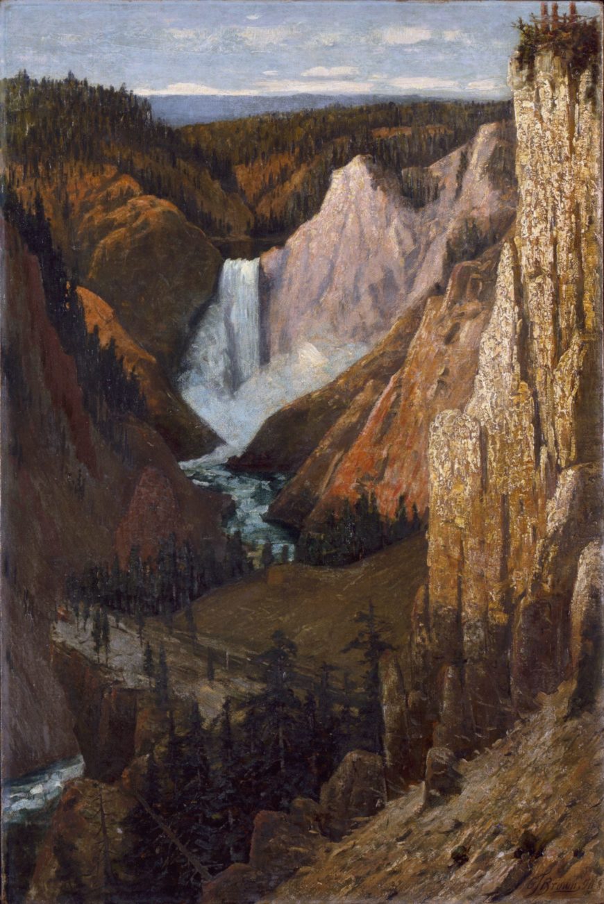
    Figure \(\PageIndex{27}\): Grafton Tyler Brown, View of the Lower Falls, Grand Canyon of the Yellowstone, 1890, oil on canvas, 30 1/4 x 20 1/8″ / 76.9 x 51.2 cm. (Smithsonian American Art Museum)

    Theodore Roosevelt in Yellowstone National Park, c. 1903 ( NPS Photo)

    Figure \(\PageIndex{28}\): Theodore Roosevelt in Yellowstone National Park, c. 1903 ( NPS Photo)

    In May of 1903, the twenty-sixth President of the United States, Theodore Roosevelt, made a visit to the state of Arizona as a part of his Western tour across the country during the first term of his presidency. He had come expressly to see the Grand Canyon, a natural wonder not only particular to America, but to the world—one of the nation’s crowning glories. In a speech delivered at the canyon on May 6, Roosevelt eloquently articulated what would become the defining mission statement of the conservation movement in America throughout the twentieth century:

    “In the Grand Canyon, Arizona has a natural wonder which, so far as I know, is in kind absolutely unparalleled throughout the rest of the world. I want to ask you to do one thing in connection with it in your own interest and in the interest of the country to keep this great wonder of nature as it now is…Leave it as it is. You cannot improve on it. The ages have been at work on it, and man can only mar it. What you can do is to keep it for your children, your children’s children, and for all who come after you, as one of the great sights which every American, if he can travel at all, should see.”

    (Theodore Roosevelt, Grand Canyon Speech, May 6, 1903)

    “Leave it as it is.” A straightforward plea, but one that was intended to caution a society that had been zealous in its need for industrialization and Westward expansion throughout the nineteenth and twentieth century at the expense of dwindling natural resources.

    Grafton Tyler Brown in his studio, c. 1880 (photo: Smithsonian Institution Archives)

    Figure \(\PageIndex{29}\): Grafton Tyler Brown in his studio, c. 1880 (photo: Smithsonian Institution Archives)

    The 1890 painting above of the falls of the Grand Canyon of the Yellowstone by Grafton Tyler Brown exemplifies the sentiment behind Roosevelt’s impassioned speech. Grafton Brown, the first African American artist to paint extensive scenes of the West and Pacific Northwest, understood implicitly that he was painting a view of a rare natural monument to preserve for posterity.

    When Grafton Brown came to Yellowstone National Park in Wyoming, the park was officially only 18 years old (President Ulysses Grant had signed its status into law on March 1, 1872). Brown had settled in Portland, Oregon in 1866 after a prolific career as a lithographer and cartographer in San Francisco in the 1860s, nearly a decade after the heady days of the California gold rush. In 1890, Brown traveled to Yosemite and Yellowstone to paint its signature features, its geysers, mountains, canyons, and falls, for audiences who were hungry for the curiosities and wonders of the West.

    Grafton Tyler Brown, Old Faithful Geyser, Yellowstone National Park, 1887, oil on canvas, 22 x 3" / 55.9 x 76.2 cm (Stark Museum of Art, Orange, Texas)

    Figure \(\PageIndex{30}\): Grafton Tyler Brown, Old Faithful Geyser, Yellowstone National Park, 1887, oil on canvas, 22 x 3″ / 55.9 x 76.2 cm (Stark Museum of Art, Orange, Texas)

    Tourists at the Grand Geyser, Yellowstone, c. 1912 (photo courtesy of the Library of Congress)

    Figure \(\PageIndex{31}\): Tourists at the Grand Geyser, Yellowstone, c. 1912 (photo courtesy of the Library of Congress)

    The opening of the Northern Pacific Railway in 1883, which linked the states of the Great Lakes to the West towards Montana, facilitated a surge in tourism and travel to the newly appropriated National Parks. When Rudyard Kipling visited Yellowstone in 1889, he wrote in his journals that he encountered “The Wonderland” one has only read about in books. On gazing at the splendor of the falls at the Yellowstone’s Grand Canyon, Kipling, recounted his awe:

    “All I can say is without warning or preparation, I looked into a gulf 1,700 feet deep with eagles and fish hawks circling far below. The sides of that gulf were one wild welter of color—crimson, emerald, cobalt, ochre, amber, honey splashed with port wine, snow white, vermillion, lemon, and silver gray in wide washes. So far below that no sound of its strife could reach us. Now I know what it is to sit enthroned amid the clouds of sunset.”

    It is this view that Grafton Tyler Brown shows us in his 1890 painting of the falls. Brown focuses the central image at an upward right angle looking down towards the falls and the canyon so that the viewer experiences a sense of being engulfed in the upward rising of the red cliffs and the surging blue spray. The grandeur and majesty described by Kipling is conveyed in Brown’s image through the careful play of dark and light, as the sun spreads across the top half of the falls and canyon in a diagonal sweep covering the pines and the bridge on the left in shadow. Though Brown’s image of the falls emphasizes their dramatic beauty, it is different from the familiar paintings of the West’s mountains and canyons by artists like Albert Bierstadt and Thomas Moran with their overt religious symbolism and deeply scaled, dramatic use of light.

    Albert Bierstadt, Yosemite Valley, 1868, oil on canvas, 91.44 × 137.16 cm / 36 × 54 inches (Oakland Museum of California)

    Figure \(\PageIndex{32}\): Albert Bierstadt, Yosemite Valley, 1868, oil on canvas, 91.44 × 137.16 cm / 36 × 54″ (Oakland Museum of California)

    Brown’s background as a lithographer and cartographer inclined him towards rendering a more scientific, de-romanticized image of the Grand Canyon of the Yellowstone. The skills that Brown had learned as a cartographer and draftsman in San Francisco in the 1860s gave him an analytical eye with which to draw and paint the Grand Canyon with precision and clarity free from religious or sentimental associations.

    Grafton Tyler Brown, View of Yosemite Valley, 1886, oil on canvas, 29 3/4 x 17 1/2 inches / 75.6 x 44.5 cm (Brooklyn Museum of Art)

    Figure \(\PageIndex{33}\): Grafton Tyler Brown, View of Yosemite Valley, 1886, oil on canvas, 29 3/4 x 17 1/2″ / 75.6 x 44.5 cm (Brooklyn Museum)

    Throughout the late nineteenth century, there was palpable anxiety felt by many across America that the country’s vast natural resources were being irrevocably diminished and destroyed as the nation industrialized and expanded Westward. The United States census of 1890 contended that with each passing year the development in the name of progress was “redeeming wilderness by the hand of man.” [1] As railroads stretched across the country, Native Americans were systemically driven from their homelands and forced onto reservations. The once vast bison herds were being hunted, forests cut for pasture, and the once abundant passenger pigeon was driven to extinction. The bountiful American Eden seemed to be vanishing. It wouldn’t be until the late nineteenth century with the pioneering efforts of conservationists like John Muir, George Bird Grinnell, and Theodore Roosevelt, that Americans would become concerned with safeguarding their land and wildlife.

     Buffalo Soldiers in the 24th Infantry carrying out patrol duties in Yosemite, c. 1899 (Yosemite Research Library)

    Figure \(\PageIndex{34}\): Buffalo soldiers in the 24th Infantry carrying out patrol duties in Yosemite, c. 1899 (Yosemite Research Library)

    Though Grafton Tyler Brown was the first black painter to devote himself to depicting scenes of the Pacific Northwest and the West, the history of African Americans within the National Park system is a rich and varied one. Between 1891 and 1913, the soldiers of the 9th and 10th Cavalry and the 24th and 25th Infantry, the Buffalo Soldiers, were assigned with protecting Yosemite National Park and Sequoia National Park from poachers and timber thieves. Not only did these first park rangers face the routine challenge of having to assert their authority against those who refused to recognize the protected status of the park’s trees and wildlife, but the added burden of racism—so endemic at the time in post-Reconstruction era America—put the Buffalo Soldiers in a dangerous position.

    Brown was often the subject of commonplace racial prejudice in San Francisco during the 1860s, a somewhat boisterous coastal boom-town in the aftermath of the Gold Rush that was filled with transplanted Southerners and Midwesterners. Due to his mixed race background, he was often referred to as a “mulatto” or “quadroon,” meaning that he perhaps had three Caucasian grandparents. Living and working in the West with its semi-lawless frontier towns and pockets of intolerance must have been a challenging and emotionally trying experience for a sensitive, educated Eastern-born son of a freedman, but Brown’s prolific body of work in the thirty years after he moved to San Francisco exemplify his remarkable talent and endurance as an artist.

    Grafton Tyler Brown, Map of Virginia City, Nevada Territory, c. 1864, published by the C.C. Kuchel Company in San Francisco

    Figure \(\PageIndex{35}\): Grafton Tyler Brown, Map of Virginia City, Nevada Territory, c. 1864, published by the C.C. Kuchel Company in San Francisco

    By 1893, Brown had settled in St. Paul, Minnesota where he began work as a cartographer and consultant with the U.S. Army Corps of Engineers and the city’s engineering department. He would remain in Minnesota until his death in 1918.

    Grafton Tyler Brown’s career showcases the astonishing efforts of an extraordinary, yet sadly, relatively ignored artist who persevered despite the racial intolerance of the late nineteenth century to forge a fascinating body of work that painstakingly documents the beauty of America’s western landscapes.

    1. As quoted by Dayton Duncan, “George Melendez Wright and the National Park Idea,” National Park Service Centennial Essay Series

    Go deeper

    Robert J. Chandler, San Francisco Lithographer: African American Artist Grafton Tyler Brown (University of Oklahoma Press, 2014).

    Dreck Spurlock Wilson, ed., African-American Architects: A Biographical Dictionary, 1865-1945 (Routledge, 2004).

    William Loren Katz, The Black West: A Documentary and Pictorial History of the African American Role in the Westward Expansion of the United States (Touchstone, 1996).

    1907-08
    Before Penn Station, Bellows & old NYC

    The awesome beauty of a large hole in the earth, dug to bring railroads to Manhattan.

    Before Penn Station, Bellows & old NYC

    The awesome beauty of the hole dug for Pennsylvania Station

    by and

    Video \(\PageIndex{6}\): George Bellows, Pennsylvania Station Excavation, c. 1907–08, oil on canvas, 79.2 x 97.1 cm (Brooklyn Museum). Speakers: Margarita Karasoulas, Assistant Curator of American Art, Brooklyn Museum and Dr. Steven Zucker

    Test your knowledge with a quiz

    Key points

    • George Bellows documents the construction site for the majestic Pennsylvania Station, part of a process of modernizing New York City through transportation networks in the early 20th century. This project also involved tunneling railway lines under the Hudson River, physically connecting New York to national transportation networks.
    • In Pennsylvania Station, Bellows does not celebrate the triumph of technology, but instead suggests the underside of the progress. This construction project displaced thousands of residents of the Tenderloin district, including African-American communities and recent immigrants.
    • Pennsylvania Station was demolished in 1963 to make way for a modern terminal and Madison Square Garden. Outrage over the destruction of this Beaux-Arts building helped to create the New York City Landmarks Preservation Commission, which now registers and protects significant buildings and sites.

    More to think about

    Compare Bellows’s Pennsylvania Station with this documentary photograph of the excavation project. What details are included in both images? What does Bellows add, or leave out, which suggests his more critical opinion of urban progress?

    c. 1910
    Wearing a force of nature

    The Yup’ik peoples, in one of the world’s coldest climates, made these ceremonial masks during the long winters.

    Wearing a force of nature

    A Yup’ik North Wind Mask

    by

    North Wind Mask (Negakfok), Alaska, Yup'ik, early 20th century, wood and feathers (Metropolitan Museum of Art)

    Figure \(\PageIndex{36}\): North Wind Mask (Negakfok), Alaska, Yup’ik, early 20th century, wood and feathers (Metropolitan Museum of Art)

    The Bering Sea, on the western coast of Alaska, is home to the Yup’ik peoples. This area has one of the world’s coldest climates, making for very challenging living conditions. Yup’ik men carved and painted masks to occupy them while indoors during the long dark winter months (when temperatures could fall to -48 degrees Fahrenheit).

    These masks played important social and ceremonial functions during dances, actively participating in the communal, spiritual life of the Yup’ik. Masked dances celebrated spiritual transformation, but were also intended to herald the coming of springtime or to bring good fortune to an upcoming hunt.

    The Yup’ik

    The Yup’ik, or Yupik (“Real People”), people come from Alaska (comprised of the Central Yup’ik and the Alutiiq). They are related to other indigenous groups or First Nations including the Inuit in Canada, the Yuiit or Siberian Yupik (also referred to as Chukchi in Siberia) and Iñupiat in Alaska, who have all been incorrectly lumped together as “Eskimos.”

    Prior to contact with foreigners (such as Russians, Europeans, and Euro-Americans), the Yup’ik turned to the ocean for their livelihood. They fished and hunted sea mammals, and often moved with the seasons to follow these sources of food. Many Yup’ik communities still live along the Alaskan coast—and continue to draw on these natural resources.

    Edward S. Curtis, A man wearing a ceremonial mask of the Nunivak style, c. 1929, photograph (Edward S. Curtis Collection, Library of Congress)

    Figure \(\PageIndex{37}\): Edward S. Curtis, A man wearing a ceremonial mask of the Nunivak style (Nunivak is an island in the Bering Sea), c. 1929, photograph (Edward S. Curtis Collection, Library of Congress)

    Making Masks

    Masking practices formed a vital component of Yup’ik culture. Masks were often made in pairs, and after they were used, the masks were typically discarded or destroyed. Only the most important—often those made and worn by the ritual specialist—might be kept and reused.

    Yup´ik mask, c. 1910, Good News Bay, Alaska, driftwood, baleen, feathers, paint, cotton twine, 49 x 39 cm (National Museum of the American Indian)

    Figure \(\PageIndex{38}\): Yup´ik mask, c. 1910, Good News Bay, Alaska, driftwood, baleen, feathers, paint, cotton twine, 49 x 39 cm (National Museum of the American Indian)

    Young men learned to carve by observing their family members producing masks. Ritual or spiritual specialists (frequently referred to today as “shamans”) often oversaw the carving of masks, but artists also added their own touches to them. No two masks were identical, and each had its own story.

    Many different materials were used to create Yup’ik masks. In a wonderful, animated mask from around 1910 now in the National Museum of the American Indian in New York (left), a Yupik carver used driftwood, baleen, feathers, paint, and cotton twine to create a mask representing a grinning face.

    The Metropolitan Museum of Art’s early twentieth-century mask (image at the top of the page) uses fewer materials—wood, paint, and feathers—and it shows Negakfok, or the North Wind (also called “the spirit that likes cold and stormy weather”). Imagine that when someone participated in a ceremony and wore this mask, the dangling wood pieces collided making noise—evoking not only the movement of wind, but also the noise it makes. The white spots may symbolize snowflakes. It calls to mind the experience of an icy wind whipping up snow—evoking the cold winters of western Alaska.

    “Eskimo medicine man and sick boy” from the Library of Congress

    Figure \(\PageIndex{39}\): Shaman healing a sick boy, c. 1900-1930, Library of Congress

    Masking Ceremonies

    Making masks and participating in performances helped to forge social bonds and to engage with beings in the spirit world. These beings were not only people, but also animals, and elements of the environment, and sometimes even hybrids. Spirits could be embodied by living creatures as well as objects like hunting tools, so it was crucial to respect the environment in which one lived. During ceremonies, masks transformed the individual wearing it into a spirit made manifest in the material world. This element of transformation is evident in the appearance of many masks that combine animal and human elements with others that relate to the environment. Men typically wore these masks during ceremonies, while women might use finger masks to animate their hands. Ritual specialists usually directed dances and selected which males would be masked participants.

    Beyond wearing the masks, hand drums were often used during the dances. Ceremonial clothing further animated dances and worked with the masks to transform an individual into a channel for a spirit. Think of these ceremonies as a form of storytelling, with the music and masked dancing as the primary means of conveying a narrative and making contact with the spirits that aided people living in a challenging natural environment. All of these events, including the carving and painting of masks, occurred in the communal men’s house, called a qasgiq.

    Changes in Yup’ik Traditions

    Fish mask of the Yup'ik people, wood, Yukon/Kuskokwim region (Alaska), early 20th century (Louvre, formerly in the collection of André Breton; on deposit from the Musée du quai Branly)

    Figure \(\PageIndex{40}\): Fish mask of the Yup’ik people, wood, Yukon/Kuskokwim region (Alaska), early 20th century (Louvre, formerly in the collection of André Breton; on deposit from the Musée du quai Branly)

    As the Yupik came into contact with Russians, Euro-Americans, and Europeans during the nineteenth century, they began to trade with groups beyond those who lived near by. As a result of increased contact with outsiders in the late nineteenth and early twentieth century however, some Yup’ik lifeways were altered, especially with attempts to Christianize them. One of the major changes that occured was the banning of masked dancing performances.

    Masked dances were forbidden when outsiders deemed these rituals an impediment to Christian evangelization. Some masks were confiscated. Other masks entered private collections in the early twentieth century after they were discarded after use.

    In the early twentieth century, Surrealist artists and writers collected Yup’ik masks because of their extraordinary appearance and the Surrealist interest in transformation. For instance, Andre Breton, the founder of the Surrealists, was known to have owned masks—finding inspiration in their conceptual nature. Enrico Donati, another surrealist artist, bought a mask in 1945 that recently sold in 2011 for more than two million dollars. Many of these masks were acquired from Julius Carlebach, a dealer in New York City who had sold masks to the Surrealists, and who had himself received many objects from George Gustav Heye whose collection forms the basis for the Museum of the American Indian (located in New York City and Washington, D.C.).

    Go deeper

    Negakfok mask at the Metropolitan Museum of Art

    Yup’ik Dance Clothes at the National Museum of the American Indian

    Yup’ik Mask at the National Museum of the American Indian (NY)

    Information about Arctic/Subarctic Peoples from the National Museum of the American Indian

    Janet Catherine Berlo and Ruth B Phillips, Native North American Art, 2 ed. (Oxford: Oxford University Press, 2014)

    Igor Krupnik, Yupik Transitions: Change and Survival at Bering Strait, 1900–1960 (Fairbanks: University of Alaska Press, 2013)

    “Agayuliyararput Our Way of Making Prayer,” Arctic Studies Center of the Smithsonian’s National Museum of Natural History

    1920-22
    Celebrating the modern city

    The sensations of the streets of New York City

    Celebrating the modern city

    New York City as a kaleidoscope of color, sound, and form.

    by and

    Video \(\PageIndex{7}\): Joseph Stella, The Voice of the City of New York Interpreted, 1920-22, oil and tempera on canvas (five panels), 99.75 x 270 inches overall (Purchase 1937 Felix Fuld Bequest Fund 37.288a-e, Newark Museum), a Seeing America video. Speakers: Dr. Tricia Laughlin Bloom and Dr. Steven Zucker

    Test your knowledge with a quiz

    Key Points

    • With electrification and the rise of the skyscraper, New York transformed into a modern urban metropolis in the early 20th century. Many immigrants, who often arrived from rural and agricultural communities, experienced culture shock upon their arrival.
    • Avant-garde artists like Joseph Stella experimented with ways to convey the dynamic experience of the modern city. They sought to celebrate this new industrial world and elevate it as a subject for art, often reinterpreting traditional formats, materials, or symbolism to blend elements of the old with the energy of the new.

    More to think about

    Discuss some of the ways Stella references other art forms to evoke the sounds and energy of New York City in a static painting. How do you think his use of poetry to accompany each panel expands on his visual imagery? If you were hired to create a modern art installation that would celebrate your hometown, what components and materials would you use?

    Choose one of the panels in Stella’s painting that seems to sum up your ideas of a big bustling city like New York. What are your impressions of the city based on–your own experience, images on television, movies, and other popular media? How do you think the ideas expressed in Stella’s painting from 1920 compares to the atmosphere of the city today?

    1935-38
    Frank Lloyd Wright's Fallingwater

    Think you procrastinate? Wright blew this project off for 9 months, then designed his most famous house in 2 hours.

    Frank Lloyd Wright’s Fallingwater

    An iconic American house that integrates a natural waterfall

    by

    Frank Lloyd Wright, Fallingwater (Edgar J. Kaufmann House), 1935-38, Bear Run, Pennsylvania (photo: Carol M. Highsmith Archive, Library of Congress #LC-DIG-highsm-04261)

    Figure \(\PageIndex{41}\): Frank Lloyd Wright, Fallingwater (Edgar J. Kaufmann House), 1935-38, Bear Run, Pennsylvania (photo: Carol M. Highsmith Archive, Library of Congress #LC-DIG-highsm-04261)

    Perched above a mountain cataract on a rocky hillside deep in the rugged forest of Southwestern Pennsylvania, some 90 minutes from Pittsburgh, is America’s most famous house. The commission for Fallingwater was a personal milestone for the American architect Frank Lloyd Wright, since it clearly marked a turning point in his career. After this late-career triumph, the sixty-seven year old would go on to create a series of highly original designs that would validate his claim as “The world’s greatest architect.”

    “The greatest architect of the nineteenth-century” —Philip Johnson

    The mid-1930s were among the darkest years for architecture and architects in American history; the country’s financial system had collapsed with the failure of hundreds of banks. Almost no private homes were built. Many of the architectural projects started during the boom of the late 1920s were halted for lack of funds. Now in his sixties, Wright and his new wife Olgivanna were struggling to keep Taliesin, his Wisconsin home and studio, out of foreclosure. Worse still, his peers were beginning to regard Wright as an irrelevant anachronism whose time had passed.

    In 1932 Henry-Russell Hitchcock and Philip Johnson opened the “Modern Architecture: International Exhibition” at the newly founded Museum of Modern Art in New York and simultaneously published the book International Style. This was, perhaps, the most influential architectural exhibit ever mounted in the United States and the book became a manifesto for modern architecture and would profoundly affect almost every major architectural project worldwide for the next 30 years. It focused on the work of four great “European functionalists” Walter Gropius, Ludwig Mies van der Rohe, Le Corbusier and J.J.P. Oud. Wright was largely snubbed.

    Hitchcock had praise for his early work, for its “many innovations,” but he condemned Wright for a “[l]ack of continuity in his development and his unwillingness to absorb the innovations of his contemporaries and his juniors in Europe.” Hitchcock insulted Wright further by characterizing him as “a rebel by temperament… [who] refused even the discipline of his own theories.” The catalogue calls Wright a “half-modern” throwback, one of the “last representatives of Romanticism.” Wright responded by denigrating European Modernism as an “evil crusade,” a manifestation of “totalitarianism.”

    A fellowship and a commission

    The Wrights devised an architectural apprenticeship program that came to be known as the “fellowship.” And among the first candidates was Edgar Kaufmann Jr. who became enamored with Wright after reading his biography. Kaufmann was the son of Pittsburgh department store tycoon Edgar Kaufmann Sr.; whose thirteen story downtown Pittsburgh emporium was reported to be the largest in the world. Kaufmann senior was no stranger to architectural pursuits—he was involved in numerous public projects and built several stores and homes. Kaufmann let Wright know that he had several civic architectural projects in mind for him. He and his wife Liliane were invited to Taliesin and were duly impressed.

    Fallingwater floorplan (diagram: Arsenalbubs: CC0 1.0)

    Figure \(\PageIndex{42}\): Fallingwater floorplan (diagram: Arsenalbubs, CC0 1.0)

    Frank Lloyd Wright, Fallingwater, steps to stream (Edgar J. Kaufmann House), Bear Run, Pennsylvania (photo: Daderot, CC0 1.0)

    Figure \(\PageIndex{43}\): Frank Lloyd Wright, Fallingwater, steps to stream (Edgar J. Kaufmann House), Bear Run, Pennsylvania (photo: Daderot, CC0 1.0)

    There are varying accounts regarding the circumstances that brought Kaufmann to offer Wright a chance to design a “weekend home” in the country; but we know that Wright made his first trip to the site on Bear Run, Pennsylvania in December, 1934. Wright’s apprentice Donald Hoppen has spoken of Wright’s “uncanny sense of…genius loci1 (Latin for “spirit of the place”) and from the very beginning, the architect rejected a site that presented a conventional view of the waterfall; instead, he audaciously offered to make the house part of it, stating that the “visit to the waterfall in the woods stays with me and a domicile takes shape in my mind to the music of the stream.” The South-southeast orientation gives the illusion that the stream flows, not alongside the house, but through it.

    Fastest draw in the Midwest

    Perhaps the most famous tale to come out of the lore of Fallingwater is the improbable story that Wright, after receiving the commission procrastinated for nine months until he was forced to draw up the complete plans while his patron was driving the 140 miles from Milwaukee to Taliesin. However, the essential story is validated by several witnesses. Apprentice Edgar Taffel recalled that after talking with Kaufmann on the phone, Wright “briskly emerged from his office…sat down at the table set with the plot plan and started to draw…The design just poured out of him. ‘Liliane and E.J. will have tea on the balcony…they’ll cross the bridge to walk in the woods…’ Pencils being used up as fast as we could sharpen them….Erasures, overdrawing, modifying. Flipping sheets back and forth. Then, the bold title across the bottom ‘Fallingwater.’ A house has to have a name.”2 There seems to be agreement that the whole process took about two hours.

    Frank Lloyd Wright, Fallingwater (Edgar J. Kaufmann House), Mill Run, Pennsylvania, 1935, Color pencil on tracing paper, 15-3/8 x 27-1/4" © The Frank Lloyd Wright Foundation

    Figure \(\PageIndex{44}\): Frank Lloyd Wright, Fallingwater (Edgar J. Kaufmann House), Mill Run, Pennsylvania, 1935, Color pencil on tracing paper, 15-3/8 x 27-1/4″ © The Frank Lloyd Wright Foundation

    Organic architecture

    Edgar Kaufmann Jr. pointed out that Wright’s famous concept of “Organic Architecture” stems from his Transcendentalist background. The belief that human life is part of nature. Wright even incorporated a rock outcropping that projected above the living room floor into his massive central hearth, further uniting the house with the earth. “Can you say” Wright challenged his apprentices “when your building is complete, that the landscape is more beautiful than it was before?”3

    In his book, Fallingwater Rising: Frank Lloyd Wright, E. J. Kaufmann, and America’s Most Extraordinary House, Franklin Toker wrote that,

    this delicate synthesis of nature and the built environment probably counts as the main reason why Fallingwater is such a well-loved work. The contouring of the house into cantilevered ledges responds so sympathetically to the rock strata of the stream banks that it does make Bear Run a more wondrous landscape than it had been before.4

    Frank Lloyd Wright, Fallingwater (Edgar J. Kaufmann House), Bear Run, Pennsylvannia, 1937 (photo: Lykantrop)

    Figure \(\PageIndex{45}\): Frank Lloyd Wright, Fallingwater (Edgar J. Kaufmann House), Bear Run, Pennsylvannia, 1937 (photo: Lykantrop)

    Wright further emphasizes the connection with nature by liberal use of glass; the house has no walls facing the falls, only a central stone core for the fireplaces and stone columns. This provides elongated vistas leading the eye out to the horizon and the woods. Vincent Scully has pointed out that this reflects “an image of Modern man caught up in constant change and flow, holding on…to whatever seems solid but no longer regarding himself as the center of the world.”5 The architect’s creative use of “corner turning windows” without mullions causes corners to vanish. Wright even bows to nature by bending a trellis beam to accommodate a pre-existing tree.

    Frank Lloyd Wright, Fallingwater, detail with tree (Edgar J. Kaufmann House), 1937 (photo: Daderot, CC0 1.0)

    Figure \(\PageIndex{46}\): Frank Lloyd Wright, Fallingwater, detail with tree (Edgar J. Kaufmann House), 1937 (photo: Daderot, CC0 1.0)

    Influences

    Walter Gropius and Adolf Meyer, competition entry for the Chicago Tribune Tower, 1922, perspective drawing, 22.5 x 13.3cm, gelatin silver print sheet (Harvard Art Museums)

    Figure \(\PageIndex{47}\): Walter Gropius and Adolf Meyer, competition entry for the Chicago Tribune Tower, 1922, perspective drawing, 22.5 x 13.3 cm, gelatin silver print sheet (Harvard Art Museums)

    Although he denied it, Wright was influenced by every conceivable architectural style, but Fallingwater owes little to his previous designs (the only exceptions being perhaps the use of irregular stones that are also found on Taliesin and his interest in strong horizontal lines). At Fallingwater, he appears to be more concerned with responding to the European Modernist design that he had in part inspired—but that had since eclipsed him. In effect, he set out to beat the Europeans at their own game, using elements of their idiom. We see, for example, inspiration drawn from the balconies of Gropius’ design for the Chicago Tribune Tower competition, though instead of the stark white of the International Style, he paints his balconies a warmer, earthen tone in deference to nature and perhaps the Adobe dwellings of the American Southwest.

    Fallingwater falling down?

    The Kaufmanns loved Wright’s radical proposal to literally suspend the house over the waterfall. But Edgar Kaufmann Sr., ever the pragmatic business man (who had also studied engineering for a year at Yale) prudently sent a copy of Wright’s blueprints to his engineer; who found the ground unstable and did not recommend that he proceed with the house. Wright was not happy with his client’s lack of faith, but permitted an increase in the number and diameter of the structure’s steel reinforcements—Kaufmann agreed to proceed. Its worth noting that the engineer’s warnings later proved valid, an issue that “haunted” Wright for the rest of his life.

    Frank Lloyd Wright, Frederick C. Robie House, Historic American Buildings Survey, Cervin Robinson, Photographer, 18 August 1963, exterior from southwest, 5757 Woodlawn Avenue, Chicago, Cook County, IL, 5 x 7" (Library of Congress HABS ILL,16-CHIG,33--3)

    Figure \(\PageIndex{48}\): Frank Lloyd Wright, Frederick C. Robie House, Historic American Buildings Survey, Cervin Robinson, Photographer, 18 August 1963, exterior from southwest, 5757 Woodlawn Avenue, Chicago, Cook County, IL, 5 x 7″ (Library of Congress HABS ILL,16-CHIG,33–3)

    Wright is famous for pushing the architectural envelope for dramatic effect. We see this is in the vast cantilevered wooden roof of Robie House in Chicago. In Fallingwater he chose ferro-concrete for his cantilevers, this use of reinforced concrete for the long suspended balconies was revolutionary. He boldly extended the balcony of the second floor master bedroom soaring six feet beyond the living room below.

    Frank Lloyd Wright, Fallingwater, steps to stream (Edgar J. Kaufmann House), Bear Run, Pennsylvania (photo: Daderot, CC0 1.0)

    Figure \(\PageIndex{49}\): Frank Lloyd Wright, Fallingwater, steps to stream (Edgar J. Kaufmann House), Bear Run, Pennsylvania (photo: Daderot, CC0 1.0)

    However, due to the lack of proper support, cracks began appearing in the balcony floors soon after they were poured. Over the years since, cracks have been repeatedly repaired as the cantilevers continued to sag. By 2001 some of the 15 foot cantilevers had fallen more than 7 inches. To avoid a complete collapse, an ingenious system was devised using tensioned cables to correct the problem and stabilize Wright’s masterwork.

    Almost from the day of its completion, Fallingwater was celebrated around the world. The house and its architect were featured in major publications including the cover of Time Magazine. Over the years its fame has only increased. According to Franklin Toker, Fallingwater’s most important contribution to Modern Architecture is surely the “acceptance of Modern architecture itself.”

    1. Donald W. Hoppen, The Seven Ages of Frank Lloyd Wright: The Creative Process, Dover Publications: New York, 1993, page 23.

    2. Edgard Tafel, Years with Frank Lloyd Wright: Apprentice to Genius, Courier Dover Publications, 1979.

    3. Hoppen, page 97.

    4. Franklin Toker, Fallingwater Rising: Frank Lloyd Wright, E. J. Kaufmann, and America’s Most Extraordinary House, Alfred A. Knopf: New York, 2003, np.

    5. Meryle Secrest, Frank Lloyd Wright: A Biography, University of Chicago Press: Chicago, 1992, page 168.

    1953
    Cars, highways, and isolation in Postwar America

    There is no open road here.

    Cars, highways, and isolation in Postwar America

    George Tooker, Highway

    by and

    Video \(\PageIndex{8}\): George Tooker, Highway, 1953, egg tempera on gesso hardboard, 58.1 x 45.4 cm (Terra Foundation for American Art, Daniel J. Terra Collection, 1992.134 © Estate of George Tooker). Speakers: Peter John Brownlee, Curator, Terra Foundation of American Art, and Dr. Steven Zucker

    Test your knowledge with a quiz

    Key points

    • The post-World War II era was a period of economic prosperity and growth in America. The automobile came to be a symbol for postwar wealth, and the dream of the open road was joined with the construction of new interstate highways.
    • While technological advances such as the automobile and television had the capability to bring people together, they were also new products that facilitated individual, rather than communal, experiences. Some people considered these innovations a threat to American culture, as people were divided and isolated by these new products.
    • George Tooker’s Highway presents a dystopian vision, with a dehumanized, unnatural landscape populated with menacing machines and isolated people. He blocks the viewer’s vision, instead confronting them with an elevated highway that seems to go nowhere.

    More to think about

    The video discussion of George Tooker’s Highway describes anxieties around how American culture following World War II became centered around individual rather than community experiences. How would you compare those anxieties to concerns about modern American culture? What might today’s version of this painting look like?

    1970

    Entropy and environment at Spiral Jetty

    Drought and rain govern when this work of art in Utah’s Great Salt Lake can be seen.

    Entropy and environment at Spiral Jetty

    Drought and rain govern how this work of art is seen

    by

    Video \(\PageIndex{9}\): Robert Smithson, Spiral Jetty, 1970, Rozel Point, Great Salt Lake, Utah, 1500 (if unwound) x 15 foot spiral of basalt, sand, and soil, ©Holt-Smithson Foundation Speakers: Dr. Steven Zucker and Dr. Beth Harris

    A monument to paradox and transience

    A loud abrasive buzzing bellows from the nightstand and I raise my head, only to be blinded by the red light emanating from the small—in size, not volume—machine against a backdrop of pure blackness. 4:00 A.M. Oy. I’m immediately beset by the eternal morning conflict: ten more minutes of sleep vs. the rush of adrenaline that wants to start the adventures that await. The latter quickly usurps the former as I realize today is September 25th, a day I’ve waited for my entire life (metaphorically speaking) and actually been counting down to since the spring. It’s Spiral Jetty day.

    Robert Smithson, Spiral Jetty, 1970 (Great Salt Lake, Utah) (photo: Gianfranco Gorgoni) ©Holt-Smithson Foundation

    Figure \(\PageIndex{50}\): Robert Smithson, Spiral Jetty, 1970 (Great Salt Lake, Utah) (photo: Gianfranco Gorgoni) ©Holt-Smithson Foundation

    I bound out of bed, Gianfranco Gorgoni’s seminal photograph of Robert Smithson’s iconic earth work on repeat in my head as I shower and “pack” for the daylong adventure that will take me to a remote area of Utah. I meet the rest of my party at the gate at LAX and it’s immediately clear from the conversation that we’ve all arrived at this moment with decades of expectation accumulated. How would the experience compare to the visions (particular to each person) we had all conjured up over the years? Would the jetty “deliver” the transformative experience we all sought? Or would it fall victim to a case of excessively high and unattainable expectations? Time would tell.

    But, it would indeed take time. An hour at the airport, followed by an hour plus on the plane, then a two plus hour bus ride over the bumpiest “trail” – it certainly wasn’t a road! — imaginable, and ultimately a fifteen minute hike. Nearly eight hours after my day had begun, it came into view. At last, Spiral Jetty.

    Smaller than expected

    But…it was so…so…so small. That couldn’t possibly be it! Naturally the distance made the work appear smaller and it “grew” as we approached, but even as we stood perched on the rocks right above it, it seemed utterly dominated by the landscape. Yet another surprise, the water from the Great Salt Lake no longer permeated the rocks, but was a significant distance beyond. Between the Jetty and the lake, there was a blanket of white – a picture-perfect postcard image of a quiet winter’s morn, and yet, the “snow” wasn’t melted by the sun blazing down from above. Upon closer inspection, the “snow” was actually crystallized salt that brilliantly reflected the sun’s rays and the nearby water.

    We walked about the Jetty with the sun hot upon our skin, the smell of the salt air filling our nose and lungs, and the feel of salt crystals on our fingers (having knelt to examine the minerals that carpeted the environ). An all-consuming, olfactory experience. We then decided to make our way across the white blanket to the water’s edge, fighting off fears that the salt, which had the distinct characteristics of ice—would “break” and we would plunge into the Great Salt Lake below (which was a physical impossibility since the water wasn’t below). From a distance the water had appeared a brilliant blue, but as we neared, gradations of color began to appear – shades of blue, purple, pink, and red – a traveler’s mirage, of sorts, and undeniably picturesque.

    We found our way up to a piece of land overlooking the jetty and sat down on the rocks to enjoy our sandwiches and “debate” Smithson’s intentions and ethical issues in conserving the work with several scholars. One of them compared Smithson’s Spiral Jetty to Monet’s Rouen Cathedral series which conveyed the same location at various times of day so that he could capture the specific lighting and other nuances of a particular moment. He said, “Smithson’s doing that here but he’s not doing it on canvas, he’s doing it out there in the elements themselves…it has that same type of specificity too it, and yet specificity that is subject to all kinds of permutations.” The question was raised about Smithson’s vision for the work, his view on its ephemerality, and whether he ever envisioned groups such as ours making the journey out to this incredibly remote location to experience his work.

    More than just a “sculpture”

    We were reminded that the physical jetty is only part of the work, which is actually a triad of the “sculpture” in the landscape, an essay by Smithson, and a film documenting the project. But, as time has marched on, the work has become embodied in the minds of the general public in a single photograph, the aforementioned image taken by Gorgoni who hovered about the work in a helicopter and captured the piece from the perfect angle so that it looked colossal, while the hills looked minuscule.

    This is due, in large part, to the fact that the jetty became submerged only a few years after it was made, and remained that way for decades. Only in the past ten years has it resurfaced and been “available” for visitation. Though Smithson may not have ever intended or even considered that people would take the time (and trouble) to visit, which begs the question that Loe posed to us, “Who is this work for?” Coolidge said the work was for Gorgoni, that Smithson had literally made it for the photograph. They all agreed that the sculpture itself is the “gesture,” but the documentation is every bit as much a part of it.

    Up until that moment, the essay, the film, and the Gorgoni photograph were the entirety of my experience with Smithson’s Spiral Jetty, which is probably true for all but a small population who’ve sought out the physical experience of the “gesture.” An object whose identity is so deeply intertwined with its documentation is fraught with complexities and paradox, but given interest in ephemerality and entropy, I’d imagine he’d be quite satisfied with the transient nature of his jetty—how it disappears and reappears at nature’s will. Such is the foundation for arguing against any conservation of the earth work, and allowing it to emerge and submerge with the tides. And yet, the thought of the work vanishing for another thirty years beneath the lake devastates me. With this debate reeling in my head, I made my way back down to the jetty. If I couldn’t be certain the work would be here waiting for my return in the distant future, I’d better take another promenade on the rocks.

    This time I separated from my friends, put down my camera, and walked the spiral in absolute silence. Though physically alone, I felt the overwhelming presence of several invisible companions: Mother Nature herself, the spirit of Robert Smithson that is somehow pervades the rocks, and God. I thought about each of them in a way that the loud noise of my crowded, urban existence prohibits. I found the transcendental calm within that often only comes to me upon reading an Emerson poem, hearing a choir sing “Amazing Grace,” or staring into the floating color-field abyss of a Mark Rothko painting.

    I began the walk back to the bus with my colleagues. We found ourselves humbled by the beauty of nature and the power of art, and hailed Smithson for giving us a reason to find our way to this breathtaking place.

    On the bumpy ride back towards town, I realized that I had made a pilgrimage in search of a monument, an icon of culture and history, but found pleasure in the aesthetic of transience instead. Spiral Jetty looked nothing like I’d imagined – a.k.a. the Gorgoni photograph – and I’m grateful. Grateful because I saw the work on September 25, 2010 and no one will ever replicate the experience of seeing it on that day, for it reinvents itself with every change of light, tide, and weather.

    Smarthistory images for teaching and learning:

    Landscape near: Smithson, Spiral Jetty, 1970Spiral Jetty terminusSmithson, Spiral Jetty, 1970Smithson, Spiral Jetty, 1970Spiral Jetty signSmithson, Spiral Jetty, 1970Road to Spiral JettyRozel Point shoreSmithson, Spiral Jetty, 1970Beth holding oolitic sandSalt on shore Rozel Point, Great Salt LakeSmithson, Spiral Jetty, 1970Smithson, Spiral Jetty, 1970Great Salt Lake at Rozel Point

    Figure \(\PageIndex{51}\): More Smarthistory images…


    This page titled 13.3: Geography and the environment is shared under a CC BY-NC-SA 4.0 license and was authored, remixed, and/or curated by Smarthistory.

    • Was this article helpful?