
1.2: Neolithic
- Page ID
- 67102

\( \newcommand{\vecs}[1]{\overset { \scriptstyle \rightharpoonup} {\mathbf{#1}} } \)
\( \newcommand{\vecd}[1]{\overset{-\!-\!\rightharpoonup}{\vphantom{a}\smash {#1}}} \)
\( \newcommand{\dsum}{\displaystyle\sum\limits} \)
\( \newcommand{\dint}{\displaystyle\int\limits} \)
\( \newcommand{\dlim}{\displaystyle\lim\limits} \)
\( \newcommand{\id}{\mathrm{id}}\) \( \newcommand{\Span}{\mathrm{span}}\)
( \newcommand{\kernel}{\mathrm{null}\,}\) \( \newcommand{\range}{\mathrm{range}\,}\)
\( \newcommand{\RealPart}{\mathrm{Re}}\) \( \newcommand{\ImaginaryPart}{\mathrm{Im}}\)
\( \newcommand{\Argument}{\mathrm{Arg}}\) \( \newcommand{\norm}[1]{\| #1 \|}\)
\( \newcommand{\inner}[2]{\langle #1, #2 \rangle}\)
\( \newcommand{\Span}{\mathrm{span}}\)
\( \newcommand{\id}{\mathrm{id}}\)
\( \newcommand{\Span}{\mathrm{span}}\)
\( \newcommand{\kernel}{\mathrm{null}\,}\)
\( \newcommand{\range}{\mathrm{range}\,}\)
\( \newcommand{\RealPart}{\mathrm{Re}}\)
\( \newcommand{\ImaginaryPart}{\mathrm{Im}}\)
\( \newcommand{\Argument}{\mathrm{Arg}}\)
\( \newcommand{\norm}[1]{\| #1 \|}\)
\( \newcommand{\inner}[2]{\langle #1, #2 \rangle}\)
\( \newcommand{\Span}{\mathrm{span}}\) \( \newcommand{\AA}{\unicode[.8,0]{x212B}}\)
\( \newcommand{\vectorA}[1]{\vec{#1}} % arrow\)
\( \newcommand{\vectorAt}[1]{\vec{\text{#1}}} % arrow\)
\( \newcommand{\vectorB}[1]{\overset { \scriptstyle \rightharpoonup} {\mathbf{#1}} } \)
\( \newcommand{\vectorC}[1]{\textbf{#1}} \)
\( \newcommand{\vectorD}[1]{\overrightarrow{#1}} \)
\( \newcommand{\vectorDt}[1]{\overrightarrow{\text{#1}}} \)
\( \newcommand{\vectE}[1]{\overset{-\!-\!\rightharpoonup}{\vphantom{a}\smash{\mathbf {#1}}}} \)
\( \newcommand{\vecs}[1]{\overset { \scriptstyle \rightharpoonup} {\mathbf{#1}} } \)
\(\newcommand{\longvect}{\overrightarrow}\)
\( \newcommand{\vecd}[1]{\overset{-\!-\!\rightharpoonup}{\vphantom{a}\smash {#1}}} \)
\(\newcommand{\avec}{\mathbf a}\) \(\newcommand{\bvec}{\mathbf b}\) \(\newcommand{\cvec}{\mathbf c}\) \(\newcommand{\dvec}{\mathbf d}\) \(\newcommand{\dtil}{\widetilde{\mathbf d}}\) \(\newcommand{\evec}{\mathbf e}\) \(\newcommand{\fvec}{\mathbf f}\) \(\newcommand{\nvec}{\mathbf n}\) \(\newcommand{\pvec}{\mathbf p}\) \(\newcommand{\qvec}{\mathbf q}\) \(\newcommand{\svec}{\mathbf s}\) \(\newcommand{\tvec}{\mathbf t}\) \(\newcommand{\uvec}{\mathbf u}\) \(\newcommand{\vvec}{\mathbf v}\) \(\newcommand{\wvec}{\mathbf w}\) \(\newcommand{\xvec}{\mathbf x}\) \(\newcommand{\yvec}{\mathbf y}\) \(\newcommand{\zvec}{\mathbf z}\) \(\newcommand{\rvec}{\mathbf r}\) \(\newcommand{\mvec}{\mathbf m}\) \(\newcommand{\zerovec}{\mathbf 0}\) \(\newcommand{\onevec}{\mathbf 1}\) \(\newcommand{\real}{\mathbb R}\) \(\newcommand{\twovec}[2]{\left[\begin{array}{r}#1 \\ #2 \end{array}\right]}\) \(\newcommand{\ctwovec}[2]{\left[\begin{array}{c}#1 \\ #2 \end{array}\right]}\) \(\newcommand{\threevec}[3]{\left[\begin{array}{r}#1 \\ #2 \\ #3 \end{array}\right]}\) \(\newcommand{\cthreevec}[3]{\left[\begin{array}{c}#1 \\ #2 \\ #3 \end{array}\right]}\) \(\newcommand{\fourvec}[4]{\left[\begin{array}{r}#1 \\ #2 \\ #3 \\ #4 \end{array}\right]}\) \(\newcommand{\cfourvec}[4]{\left[\begin{array}{c}#1 \\ #2 \\ #3 \\ #4 \end{array}\right]}\) \(\newcommand{\fivevec}[5]{\left[\begin{array}{r}#1 \\ #2 \\ #3 \\ #4 \\ #5 \\ \end{array}\right]}\) \(\newcommand{\cfivevec}[5]{\left[\begin{array}{c}#1 \\ #2 \\ #3 \\ #4 \\ #5 \\ \end{array}\right]}\) \(\newcommand{\mattwo}[4]{\left[\begin{array}{rr}#1 \amp #2 \\ #3 \amp #4 \\ \end{array}\right]}\) \(\newcommand{\laspan}[1]{\text{Span}\{#1\}}\) \(\newcommand{\bcal}{\cal B}\) \(\newcommand{\ccal}{\cal C}\) \(\newcommand{\scal}{\cal S}\) \(\newcommand{\wcal}{\cal W}\) \(\newcommand{\ecal}{\cal E}\) \(\newcommand{\coords}[2]{\left\{#1\right\}_{#2}}\) \(\newcommand{\gray}[1]{\color{gray}{#1}}\) \(\newcommand{\lgray}[1]{\color{lightgray}{#1}}\) \(\newcommand{\rank}{\operatorname{rank}}\) \(\newcommand{\row}{\text{Row}}\) \(\newcommand{\col}{\text{Col}}\) \(\renewcommand{\row}{\text{Row}}\) \(\newcommand{\nul}{\text{Nul}}\) \(\newcommand{\var}{\text{Var}}\) \(\newcommand{\corr}{\text{corr}}\) \(\newcommand{\len}[1]{\left|#1\right|}\) \(\newcommand{\bbar}{\overline{\bvec}}\) \(\newcommand{\bhat}{\widehat{\bvec}}\) \(\newcommand{\bperp}{\bvec^\perp}\) \(\newcommand{\xhat}{\widehat{\xvec}}\) \(\newcommand{\vhat}{\widehat{\vvec}}\) \(\newcommand{\uhat}{\widehat{\uvec}}\) \(\newcommand{\what}{\widehat{\wvec}}\) \(\newcommand{\Sighat}{\widehat{\Sigma}}\) \(\newcommand{\lt}{<}\) \(\newcommand{\gt}{>}\) \(\newcommand{\amp}{&}\) \(\definecolor{fillinmathshade}{gray}{0.9}\)Neolithic art
The way we live today, settled in homes, close to other people in towns and cities, protected by laws, eating food grown on farms, and with leisure time to learn, explore and invent is all a result of the Neolithic revolution—the development of the technology needed to plant and harvest crops and to domesticate animals.
c. 10,0000 B.C.E. - 2000 B.C.E.
The Neolithic revolution
A settled life
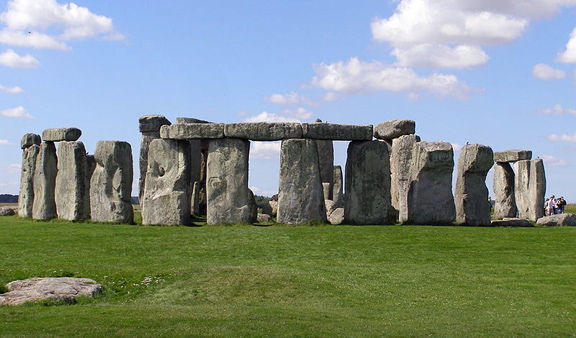
When people think of the Neolithic era, they often think of Stonehenge, the iconic image of this early time. Dating to approximately 3000 B.C.E. and set on Salisbury Plain in England, it is a structure larger and more complex than anything built before it in Europe. Stonehenge is an example of the cultural advances brought about by the Neolithic revolution—the most important development in human history. The way we live today, settled in homes, close to other people in towns and cities, protected by laws, eating food grown on farms, and with leisure time to learn, explore and invent is all a result of the Neolithic revolution, which occurred approximately 11,500-5,000 years ago. The revolution which led to our way of life was the development of the technology needed to plant and harvest crops and to domesticate animals.
Before the Neolithic revolution, it’s likely you would have lived with your extended family as a nomad, never staying anywhere for more than a few months, always living in temporary shelters, always searching for food and never owning anything you couldn’t easily pack in a pocket or a sack. The change to the Neolithic way of life was huge and led to many of the pleasures (lots of food, friends and a comfortable home) that we still enjoy today.
Neolithic art
The massive changes in the way people lived also changed the types of art they made. Neolithic sculpture became bigger, in part, because people didn’t have to carry it around anymore; pottery became more widespread and was used to store food harvested from farms. Alcohol was first produced during this period and architecture, as well as its interior and exterior decoration, first appears. In short, people settled down and began to live in one place, year after year.
It seems very unlikely that Stonehenge could have been made by earlier, Paleolithic, nomads. It would have been a waste to invest so much time and energy building a monument in a place to which they might never return or might only return infrequently. After all, the effort to build it was extraordinary. Stonehenge is approximately 320 feet in circumference and the stones which compose the outer ring weigh as much as 50 tons; the small stones, weighing as much as 6 tons, were quarried from as far away as 450 miles. The use or meaning of Stonehenge is not clear, but the design, planning and execution could have only been carried out by a culture in which authority was unquestioned. Here is a culture that was able to rally hundreds of people to perform very hard work for extended periods of time. This is another characteristic of the Neolithic era.

Plastered skulls
The Neolithic period is also important because it is when we first find good evidence for religious practice, a perpetual inspiration for the fine arts. Perhaps most fascinating are the plaster skulls found around the area of the Levant, at six sites, including Jericho. At this time in the Neolithic, c. 7000-6,000 B.C.E., people were often buried under the floors of homes, and in some cases their skulls were removed and covered with plaster in order to create very life-like faces, complete with shells inset for eyes and paint to imitate hair and mustaches.
The traditional interpretation of these the skulls has been that they offered a means of preserving and worshiping male ancestors. However, recent research has shown that among the sixty-one plastered skulls that have been found, there is a generous number that come from the bodies of women and children. Perhaps the skulls are not so much religious objects but rather powerful images made to aid in mourning lost loved ones.
Neolithic peoples didn’t have written language, so we may never know what their creators intended. (The earliest example of writing develops in Sumer in Mesopotamia in the late 4th millennium B.C.E. However, there are scholars that believe that earlier proto-writing developed during the Neolithic period).
Additional resources:
Stonehenge (English Heritage site)
Who built Stonehenge? (English Heritage video)
Stonehenge: Clues to the past (English Heritage video)
Creating an Ancestor: The Jericho Skull at the British Museum
Smarthistory images for teaching and learning:


Jericho
A natural oasis
The site of Jericho, just north of the Dead Sea and due west of the Jordan River, is one of the oldest continuously lived-in cities in the world. The reason for this may be found in its Arabic name, Ārīḥā, which means fragrant; Jericho is a natural oasis in the desert where countless fresh water springs can be found. This resource, which drew its first visitors between 10,000 and 9000 B.C.E., still has descendants that live there today.

Biblical reference
The site of Jericho is best known for its identity in the Bible and this has drawn pilgrims and explorers to it as early as the 4th century C.E.; serious archaeological exploration didn’t begin until the latter half of the 19th century. What continues to draw archaeologists to Jericho today is the hope of finding some evidence of the warrior Joshua, who led the Israelites to an unlikely victory against the Canaanites (“the walls of the city fell when Joshua and his men marched around them blowing horns” Joshua 6:1-27). Although unequivocal evidence of Joshua himself has yet to be found, what has been uncovered are some 12,000 years of human activity.
The most spectacular finds at Jericho, however, do not date to the time of Joshua, roughly the Bronze Age (3300-1200 B.C.E.), but rather to the earliest part of the Neolithic era, before even the technology to make pottery had been discovered.

Old walls
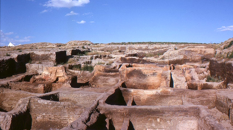
The site of Jericho rises above the wide plain of the Jordan Valley, its height the result of layer upon layer of human habitation, a formation called a Tell. The earliest visitors to the site who left remains (stone tools) came in the Mesolithic period (around 9000 B.C.E.) but the first settlement at the site, around the Ein as-Sultan spring, dates to the early Neolithic era, and these people, who built homes, grew plants, and kept animals, were among the earliest to do such anywhere in the world. Specifically, in the Pre-Pottery Neolithic A levels at Jericho (8500-7000 B.C.E.) archaeologists found remains of a very large settlement of circular homes made with mud brick and topped with domed roofs.
As the name of this era implies, these early people at Jericho had not yet figured out how to make pottery, but they made vessels out of stone, wove cloth and for tools were trading for a particularly useful kind of stone, obsidian, from as far away as Çiftlik, in eastern Turkey. The settlement grew quickly and, for reasons unknown, the inhabitants soon constructed a substantial stone wall and exterior ditch around their town, complete with a stone tower almost eight meters high, set against the inner side of the wall. Theories as to the function of this wall range from military defense to keeping out animal predators to even combating the natural rising of the level of the ground surrounding the settlement. However, regardless of its original use, here we have the first version of the walls Joshua so ably conquered some six thousand years later.
Plastered human skulls
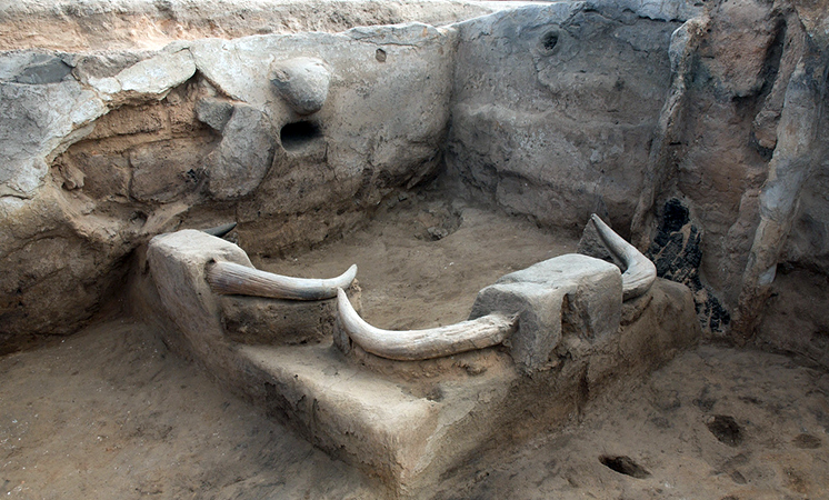
The Pre-Pottery Neolithic A period is followed by the Pre-Pottery Neolithic B (7000-5200 BCE), which was different from its predecessor in important ways. Houses in this era were uniformly rectangular and constructed with a new kind of rectangular mud bricks which were decorated with herringbone thumb impressions, and always laid lengthwise in thick mud mortar. This mortar, like a plaster, was also used to create a smooth surface on the interior walls, extending down across the floors as well. In this period there is some strong evidence for cult or religious belief at Jericho. Archaeologists discovered one uniquely large building dating to the period with unique series of plastered interior pits and basins as well as domed adjoining structures and it is thought this was for ceremonial use.

Other possible evidence of cult practice was discovered in several homes of the Pre-Pottery Neolithic town, in the form of plastered human skulls which were molded over to resemble living heads. Shells were used for eyes and traces of paint revealed that skin and hair were also included in the representations. The largest group found together were nine examples, buried in the fill below the plastered floor of one house.
Jericho isn’t the only site at which plastered skulls have been found in Pre-Pottery Neolithic B levels; they have also been found at Tell Ramad, Beisamoun, Kfar Hahoresh, ‘Ain Ghazal and Nahal Hemar. Among the some sixty-two skulls discovered among these sites, we know that older and younger men as well as women and children are represented, which poses interesting questions as to their meaning. Were they focal points in ancestor worship, as was originally thought, or did they function as images by which deceased family members could be remembered? As we are without any written record of the belief system practiced in the Neolithic period in the area, we will never know.
Additional resources:
Creating an ancestor: the Jericho Skull (from The British Museum)
Smarthistory images for teaching and learning:

The Jericho Skull
Is the plaster face on this skull modeled after a real person? Is it one of the world’s oldest portraits?
Video \(\PageIndex{1}\): Video from the British Museum
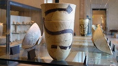
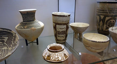
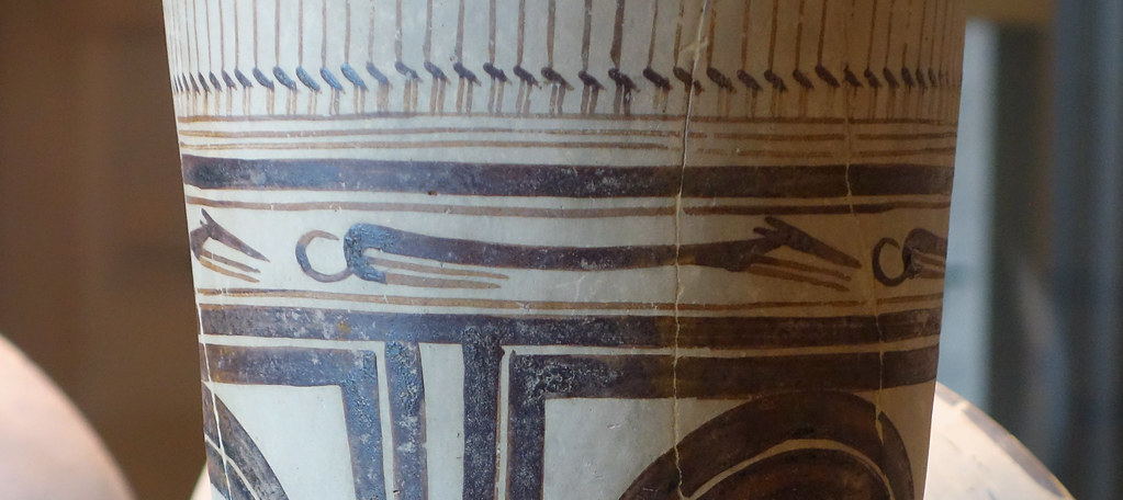
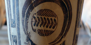
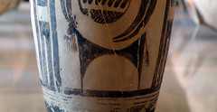
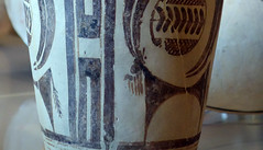
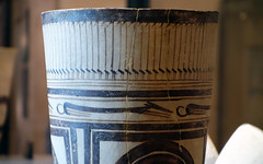
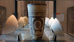
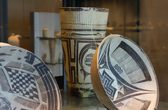
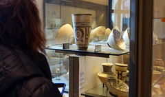
Bushel with ibex motifs
by DR. BETH HARRIS and DR. STEVEN ZUCKER
This beautiful pot was created over 5,000 years ago, and its decoration echoes its shape.
Smarthistory images for teaching and learning:


Çatalhöyük
The city of Çatalhöyük points to one of man’s most important transformations, from nomad to settled farmer.
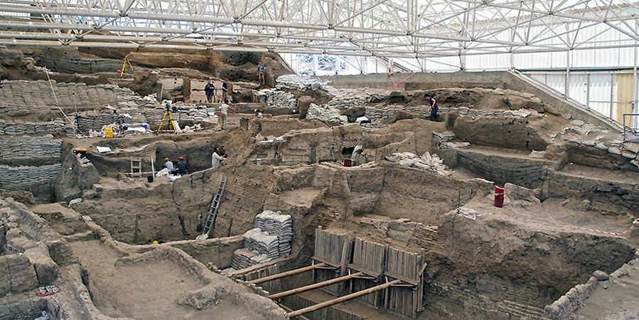
Çatalhöyük or Çatal Höyük (pronounced “cha-tal hay OOK”) is not the oldest site of the Neolithic era or the largest, but it is extremely important to the beginning of art. Located near the modern city of Konya in south central Turkey, it was inhabited 9000 years ago by up to 8000 people who lived together in a large town. Çatalhöyük, across its history, witnesses the transition from exclusively hunting and gathering subsistence to increasing skill in plant and animal domestication. We might see Çatalhöyük as a site whose history is about one of man’s most important transformations: from nomad to settler. It is also a site at which we see art, both painting and sculpture, appear to play a newly important role in the lives of settled people.

Çatalhöyük had no streets or foot paths; the houses were built right up against each other and the people who lived in them traveled over the town’s rooftops and entered their homes through holes in the roofs, climbing down a ladder. Communal ovens were built above the homes of Çatalhöyük and we can assume group activities were performed in this elevated space as well.
Like at Jericho, the deceased were placed under the floors or platforms in houses and sometimes the skulls were removed and plastered to resemble live faces. The burials at Çatalhöyük show no significant variations, either based on wealth or gender; the only bodies which were treated differently, decorated with beads and covered with ochre, were those of children. The excavator of Çatalhöyük believes that this special concern for youths at the site may be a reflection of the society becoming more sedentary and required larger numbers of children because of increased labor, exchange and inheritance needs.
Art is everywhere among the remains of Çatalhöyük, geometric designs as well as representations of animals and people. Repeated lozenges and zigzags dance across smooth plaster walls, people are sculpted in clay, pairs of leopards are formed in relief facing one another at the sides of rooms, hunting parties are painted baiting a wild bull. The volume and variety of art at Çatalhöyük is immense and must be understood as a vital, functional part of the everyday lives of its ancient inhabitants.
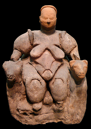
Many figurines have been found at the site, the most famous of which illustrates a large woman seated on or between two large felines. The figurines, which illustrate both humans and animals, are made from a variety of materials but the largest proportion are quite small and made of barely fired clay. These casual figurines are found most frequently in garbage pits, but also in oven walls, house walls, floors and left in abandoned structures. The figurines often show evidence of having been poked, scratched or broken, and it is generally believed that they functioned as wish tokens or to ward off bad spirits.
Nearly every house excavated at Çatalhöyük was found to contain decorations on its walls and platforms, most often in the main room of the house. Moreover, this work was constantly being renewed; the plaster of the main room of a house seems to have been redone as frequently as every month or season. Both geometric and figural images were popular in two-dimensional wall painting and the excavator of the site believes that geometric wall painting was particularly associated with adjacent buried youths.

Figural paintings show the animal world alone, such as, for instance, two cranes facing each other standing behind a fox, or in interaction with people, such as a vulture pecking at a human corpse or hunting scenes. Wall reliefs are found at Çatalhöyük with some frequency, most often representing animals, such as pairs of animals facing each other and human-like creatures. These latter reliefs, alternatively thought to be bears, goddesses or regular humans, are always represented splayed, with their heads, hands and feet removed, presumably at the time the house was abandoned.
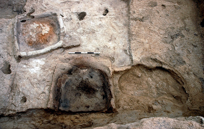
The most remarkable art found at Çatalhöyük, however, are the installations of animal remains and among these the most striking are the bull bucrania. In many houses the main room was decorated with several plastered skulls of bulls set into the walls (most common on East or West walls) or platforms, the pointed horns thrust out into the communal space. Often the bucrania would be painted ochre red. In addition to these, the remains of other animals’ skulls, teeth, beaks, tusks or horns were set into the walls and platforms, plastered and painted. It would appear that the ancient residents of Çatalhöyük were only interested in taking the pointy parts of the animals back to their homes!
How can we possibly understand this practice of interior decoration with the remains of animals? A clue might be in the types of creatures found and represented. Most of the animals represented in the art of Çatalhöyük were not domesticated; wild animals dominate the art at the site. Interestingly, examination of bone refuse shows that the majority of the meat which was consumed was of wild animals, especially bulls. The excavator believes this selection in art and cuisine had to do with the contemporary era of increased domestication of animals and what is being celebrated are the animals which are part of the memory of the recent cultural past, when hunting was much more important for survival.
Stonehenge
Recognized worldwide, Stonehenge seems an impossible task: how, and why, did prehistoric people build it?
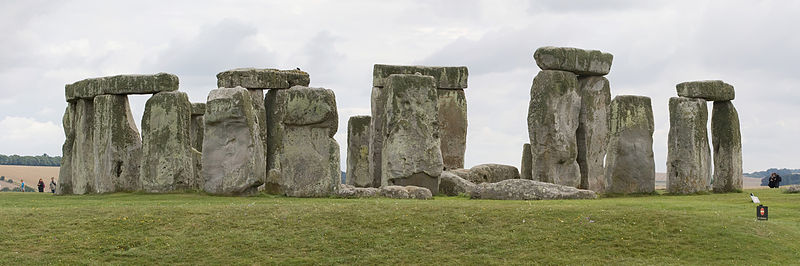
Stonehenge, on Salisbury plain in England, is one of the most recognizable monuments of the Neolithic world and one of the most popular, with over one million visitors a year. People come to see Stonehenge because it is so impossibly big and so impossibly old; some are searching for a connection with a prehistoric past; some come to witness the workings of a massive astrological observatory. The people living in the fourth millennium B.C.E. who began work on Stonehenge were contemporary with the first dynasties of Ancient Egypt, and their efforts predate the building of the Pyramids. What they created has endured millennia and still intrigues us today.
Phase one

In fact, what we see today is the result of at least three phases of construction, although there is still a lot of controversy among archaeologists about exactly how and when these phases occurred. It is generally agreed that the first phase of construction at Stonehenge occurred around 3100 B.C.E., when a great circular ditch about six feet deep was dug with a bank of dirt within it about 360 feet in diameter, with a large entrance to the northeast and a smaller one to the south. This circular ditch and bank together is called a henge. Within the henge were dug 56 pits, each slightly more than three feet in diameter, called Aubrey holes, after John Aubrey, the 17th century English archaeologist who first found them. These holes, it is thought, were either originally filled with upright bluestones or upright wooden beams. If it was bluestones which filled the Aubrey holes, it involved quite a bit of effort as each weighed between 2 and 4 tons and were mined from the Preseli Hills, about 250 miles away in Wales.
Phase two
The second phase of work at Stonehenge occurred approximately 100-200 years later and involved the setting up of upright wooden posts (possibly of a roofed structure) in the center of the henge, as well as more upright posts near the northeast and southern entrances. Surprisingly, it is also during this second phase at Stonehenge that it was used for burial. At least 25 of the Aubrey holes were emptied and reused to hold cremation burials and another 30 cremation burial pits were dug into the ditch of the henge and in the eastern portion within the henge enclosure.
Phase three
The third phase of construction at Stonehenge happened approximately 400-500 years later and likely lasted a long time. In this phase the remaining blue stones or wooden beams which had been placed in the Aubrey holes were pulled and a circle 108 feet in diameter of 30 huge and very hard sarsen stones were erected within the henge; these were quarried from nearby Marlborough Downs. These upright sarsen stones were capped with 30 lintel stones.

Each standing stone was around 13 feet high, almost seven feet wide and weighed around 25 tons. This ring of stones enclosed five sarsen trilithons (a trilithon is a pair of upright stones with a lintel stone spanning their tops) set up in a horseshoe shape 45 feet across. These huge stones, ten uprights and five lintels, weigh up to 50 tons each. Bluestones, either reinstalled or freshly quarried, were erected in a circle, half in the outer sarsen circle and half within the sarsen horseshoe. At the end of the phase there is some rearrangement of the bluestones as well as the construction of a long processional avenue, consisting of parallel banks with exterior ditches approximately 34 meters across, leading from the northeast entrance to Stonehenge, dipping to the south and eventually to the banks of the Avon river.
Questions
All three phases of the construction of Stonehenge pose fascinating questions. The first phase of work required precise planning and a massive amount of labor. Who planned the henge and who organized whom to work together in its construction? Unfortunately, remains of Neolithic villages, which would provide information about who built Stonehenge, are few, possibly because so many lie underneath later Bronze Age, Roman, Medieval and modern cities. The few villages that have been explored show simple farming hamlets with very little evidence of widely differing social status. If there were leaders or a social class who convinced or forced people to work together to build the first phase of Stonehenge, we haven’t found them. It also probably means the first phase of Stonehenge’s construction was an egalitarian endeavor, highly unusual for the ancient world.
Who were the people buried at Stonehenge during its second phase? Recent analysis of these bones has revealed that nearly all the burials were of adult males, aged 25-40 years, in good health and with little sign of hard labor or disease. No doubt, to be interred at Stonehenge was a mark of elite status and these remains may well be those of some of the first political leaders of Great Britain, an island with a ruling tradition extending all the way to the House of Windsor. They also show us that in this era, some means of social distinction must have been desirable.
Conclusions
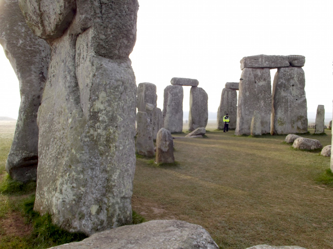
The work achieved in the long third phase of Stonehenge’s construction, however, is the one which is most remarkable and enduring. Like the first phase of Stonehenge, except on a much larger scale, the third phase involved tremendous planning and organization of labor. But, it also entailed an entirely new level of technical sophistication, specifically in the working of very hard stone. For instance, the horizontal lintel stones which topped the exterior ring of sarsen stones were fitted to them using a tongue and groove joint and then fitted to each other using a mortise and tenon joint, methods used in modern woodworking.
Each of the upright sarsens were dressed differently on each side, with the inward facing side more smoothly finished than the outer. Moreover, the stones of the outer ring of sarsens were subtly modified to accommodate the way the human eye observes the massive stones against the bright shades of the Salisbury plain: upright stones were gently widened toward the top which makes their mass constant when viewed from the ground.
The lintel stones also curve slightly to echo the circular outer henge. The stones in the horseshoe of trilithons are arranged by size; the smallest pair of trilithons are around 20 feet tall, the next pair a little higher and the largest, single trilithon in the south west corner would have been 24 feet tall. This effect creates a kind of pull inward to the monument, and dramatizes the outward Northeast facing of the horseshoe. Although there are many theories, it is still not known how or why these subtle refinements were made to Stonehenge, but their existence is sure proof of a sophisticated society with organized leadership and a lot of free time.
A solar and lunar calendar?
Of course the most famous aspect of Stonehenge is its relationship with the solar and lunar calendar. This idea was first proposed by scholars in the 18th century, who noted that the sunrise of the midsummer solstice is exactly framed by the end of the horseshoe of trilithons at the interior of the monument, and exactly opposite that point, at the center of the bend of the horseshoe, at the midwinter sunset, the sun is also aligned. These dates, the longest and shortest days of the year, are the turning point of the two great seasonal episodes of the annual calendar. Since this discovery, several other theories about astrological observation have been offered but few stand up to scrutiny together with the physical details of the monument.
Video \(\PageIndex{3}\)
Video \(\PageIndex{4}\)
Video \(\PageIndex{5}\)
Video \(\PageIndex{6}\): Video from UNESCO TV / © NHK Nippon Hoso Kyokai
Additional resources:
Discover Stonehenge from English Heritage
Virtual tour of Stonehenge, Google Cultural Institute
Who built Stonehenge (video from English Heritage)
Stone working (video from English Heritage)
Stonehenge: bluestones (video from English Heritage)
Stonehenge Clues to the Past (video from English Heritage)
Stonehenge, Avebury and Associated Sites
by UNESCO
In the south of England, circles of huge stones rose from the plains.
Video \(\PageIndex{7}\): Video from UNESCO TV / © NHK Nippon Hoso Kyokai
Stonehenge and Avebury, in Wiltshire, are among the most famous groups of megaliths in the world. The two sanctuaries consist of circles of menhirs arranged in a pattern whose astronomical significance is still being explored. These holy places and the nearby Neolithic sites are an incomparable testimony to prehistoric times. Learn more on the UNESCO World Heritage List website.
Nuragic architecture at Su Nuraxi Barumini, Sardinia
The Nuragic civilization of the island of Sardinia presents a mystery—what were their huge stone towers?
Sardinia
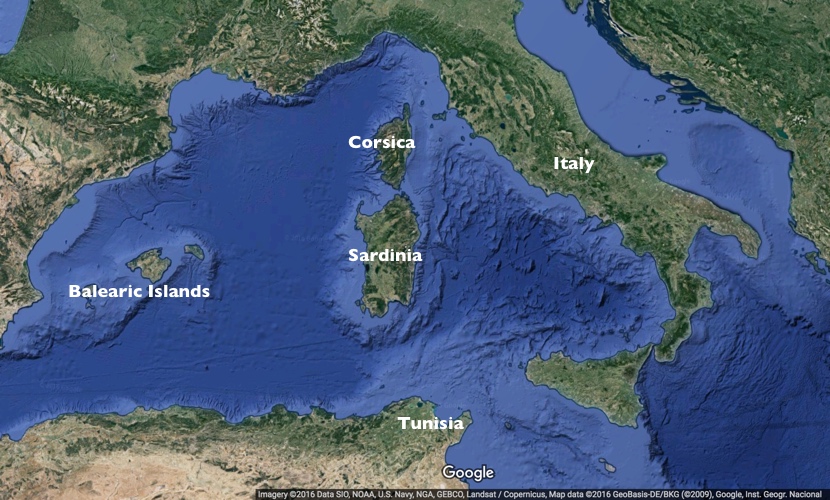
The island of Sardinia is the second largest island in the Mediterranean Sea and was home to ancient cultures. To its north lies Corsica, to its east the Italian peninsula, to its south Tunisia, and to the west the Balearic Islands. Sardinia was a key stopping point for sailors and traders for millennia and has a deep and ancient cultural heritage. The characteristic and indigenous Nuragic civilization of Sardinia stretches from the Bronze Age (c. 18th century B.C.E.) to the Roman period. This civilization derives its name from a characteristic form of monumental, stone-built tower structures known as nuraghe—some 7,000 of these enigmatic structures still dot the Sardinian landscape.
First settlers
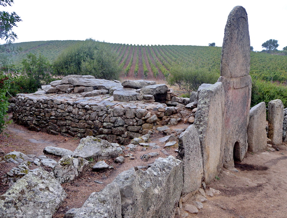
During the Paleolithic and Neolithic periods, the first human settlers of Sardinia arrived, most likely from various parts of the Mediterranean basin and Europe. The Ozieri (also known as San Michele) culture is the first identifiable settled culture in Sardinia, dating c. 3200 to 2800 B.C.E. The Ozieri people are known for village-size communities and their material culture includes “mother goddess” figurines that are common in the Mediterranean and Near East. Perhaps due to migrants arriving from the western Mediterranean, some similarities may be observed between artifacts in Sardinia and those of the Balearic islands. The altar site of Monte d’Accoddi is one such example, with its earliest phases dating c. 4,000-3,650 B.C.E. (below).

By c. 2,000 B.C.E., peoples of the Beaker culture had arrived in Sardinia, in turn producing the Bonnanaro culture (c. 1800-1600 B.C.E.), a protohistoric culture of Sardinia. This culture group represents the first stage of the so-called Nuragic civilization. The Bonnanaro culture was responsible for architectural innovations, notably the so-called “Giants’ grave,” a type of megalithic, covered gallery tomb (below).
Nuraghi
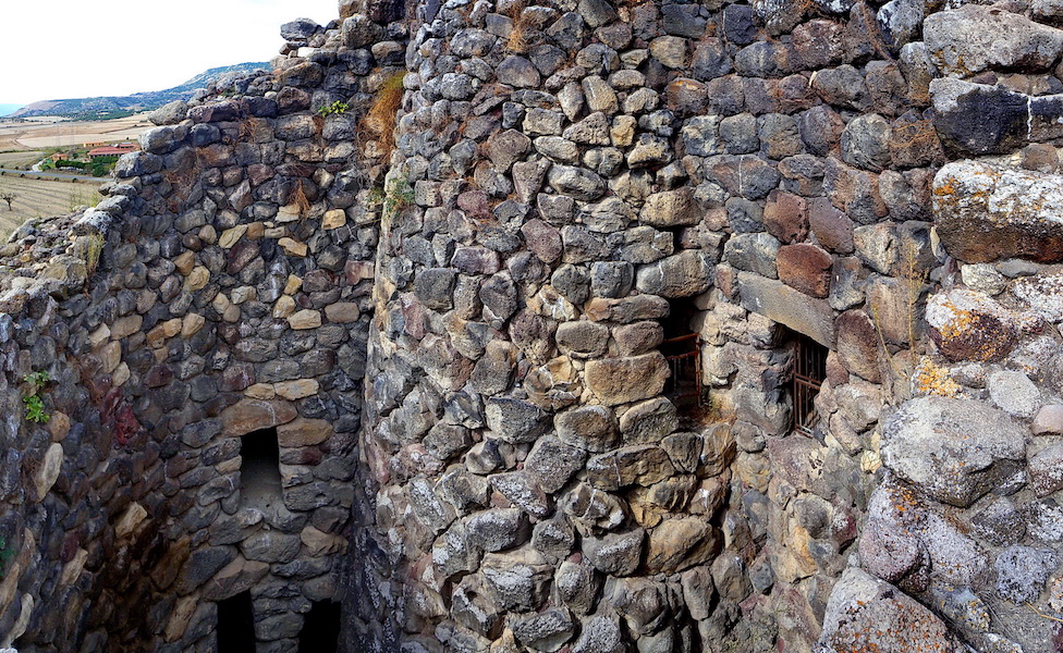
The development of the nuraghe (nuraghi in the plural—the monumental structures that Nuragic civilization takes its name from) in Bronze Age Sardinia is both an important and interesting architectural phenomenon. A nuraghe is a megalithic stone structure that usually takes the form of a truncated conical tower. The interior profile of the built tower is usually beehive-shaped, while the exterior resembles the more familiar image of a Medieval tower. The construction is dry stone (no bonding material is used). Different degrees of stoneworking are used in the structures—ranging from packed rubble to cut and dressed (shaped) stones. About 7,000 nuraghi are still evident in Sardinia, but scholars estimate that 10,000 or more originally existed. The central tower can be surrounded by an outlying wall and can sometimes be accompanied by an attendant settlement. The tower itself could stand up to 30 meters in height.
While nuragic architecture is well understood, the function of the nuraghe itself is a matter of continuing scholarly debate. Complicating this debate is the fact that very few of the island’s extant nuraghe have been scientifically excavated and studied. Some theories hold that the nuraghi were defensive structures, others that they represented cultural status symbols. Many nuraghi show evidence of continued use and re-use after the Bronze Age, mostly during the Punic and Roman phases of the island’s history.
The site of Su Nuraxi di Barumini
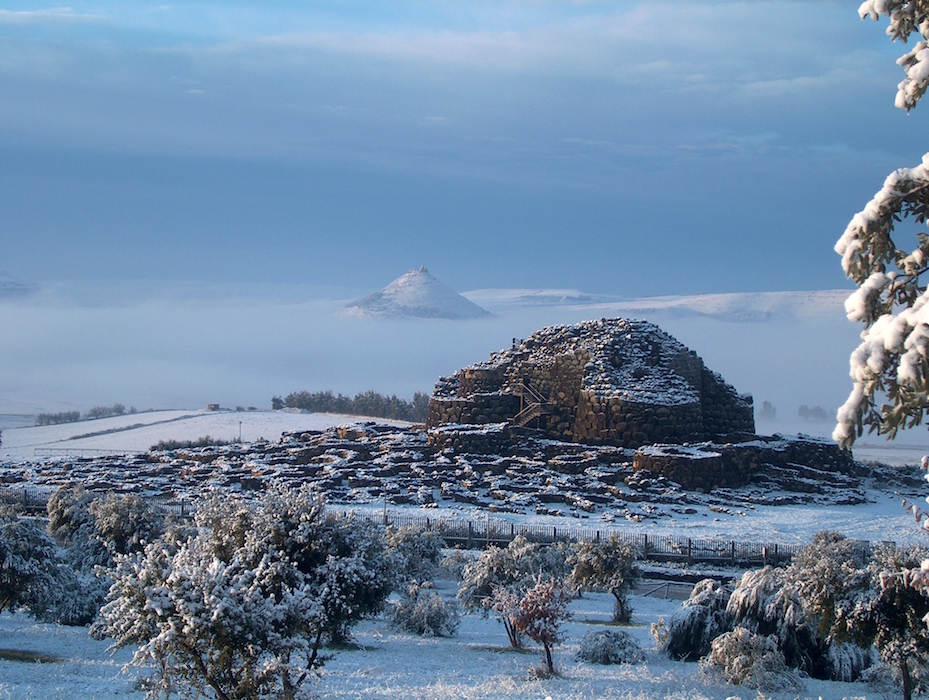
The site of Su Nuraxi di Barumini (Barumini is the name of the region in south-central Sardinia) is one of the most thoroughly studied of Sardinia’s nuraghi. The oldest part of Su Nuraxi is a central tower that stands approximately 18.6 meters high and was built from basalt between the seventeenth and thirteenth centuries B.C.E. In later phases four ancillary towers connected by a curtain wall (an outer, non-structural wall) were built surrounding the central tower. This outlying wall created a central courtyard that included a well. In the Iron Age, a curtain wall with seven lobes (heptalobate) was added to the complex.
Later in the Bronze Age—the so-called “Final” Bronze Age (c. twelfth to ninth centuries B.C.E) a village of approximately 200 huts grew up outside of the outer wall of the nuragic complex. Some of these huts showed evidence of ritual activity, and a bronze model of a nuraghe was also found. The village continued in use during the Iron Age (ninth through seventh centuries B.C.E.), again with evidence of ritual activity as well as some evidence for organization of the settlement. The complex experienced widespread destruction at the end of the Iron Age. In later Punic and Roman phases, parts of the site were reused, and there is evidence for sporadic occupation continuing to the seventh century C.E.
The site was excavated by archaeologist Giovanni Lilliu (1914-2012) who concluded that the site had a defensive nature, a fairly traditional interpretation. The site was listed as a UNESCO World Heritage site in 1997.
The Nuragic civilization, and the nuraghi themselves, remain somewhat enigmatic, but it is clear that this architectural tradition is deeply rooted in the Mediterranean. By way of material culture evidence it is possible to trace the influences of Sardinian culture to the Italian mainland where Etruscan and Italic people seem to draw inspiration from Sardinian traditions of metalworking and architecture, among others.
Additional resources:
Su Nuraxi di Barumini (UNESCO)
Sardegna Cultura—Barumini, Complesso di Su Nuraxi
Enrico Atzeni and Giovanni Pugliese Carratelli, Ichnussa: la Sardegna dalle origini all’età classica (Milan: Libri Scheiwiller, 1981).
Miriam S. Balmuth, “The Nuraghi Towers of Sardinia,” Archaeology, Vol. 34, No. 2 (March/April 1981), pp. 35-43.
Emma Blake, “Sardinia’s Nuraghi: Four Millennia of Becoming,” World Archaeology, vol. 30, no. 1, The Past in the Past: The Reuse of Ancient Monuments (Jun., 1998), pp. 59-71.
Emma Blake, “Constructing a Nuragic Locale: The Spatial Relationship between Tombs and Towers in Bronze Age Sardinia,” American Journal of Archaeology, Vol. 105, No. 2 (April 2001), pp. 145-161.
Emma Blake, Social Networks and Regional Identity in Bronze Age Italy (Cambridge: Cambridge University Press, 2014).
W. G. Cavanagh, R. R. Laxton, S. Bafico, and G. Rossi, “An Investigation into the Construction of Sardinian Nuraghi,” Papers of the British School at Rome, Vol. 55 (1987), pp. 1-74.
Stephen L. Dyson and Robert J. Rowland. Shepherds, Sailors, and Conquerors: Archeology and History in Sardinia from the Stone Age to the Middle Ages (Philadelphia: University of Pennsylvania, Museum of Archeology and Anthropology, 2007).
R. Ross Holloway, “Nuragic Tower Models and Ancestral Memory,” Memoirs of the American Academy in Rome, vol. 46 (2001), pp. 1-9
Giovanni Lilliu, “Il nuraghe di Barumini e la stratigrafia nuragica,” Studi Sardi 12-13.1 (1955) pp. 137-469.
Giovanni Lilliu, La civiltà dei sardi: dal neolitico all’età dei nuraghi (Turin: ERI, 1963).
Giovanni Lilliu and Raimondo Zucca, Su Nuraxi di Barumini (Sassari: Carlo Delfino, 2001).
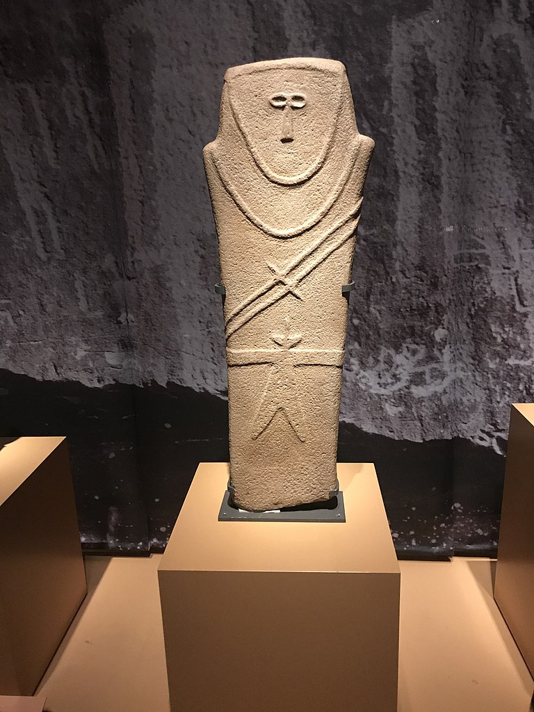
Anthropomorphic stele
This stone marker depicts an abstracted human. How should we interpret one of the Arabia’s earliest artifacts?
An anthropomorphic stele from Ha’il
This stele is tall, measuring approximately three feet high. But it is not just vertical height that makes this free-standing stone sculpture appear human, or anthropomorphic.
While both sides are sculpted, emphasis is on the front, particularly the face, chest, and waist: a trapezoidal head rests directly on squared shoulders with the outline of a face framing two closely-spaced eyes and a flattened nose; on the robed figure’s torso a necklace hangs with two cords diagonally crossing the body with an awl (a small pointed tool) attached; and at the waist, a double-bladed dagger hangs from a wide belt that continues around to the back. The sculpture is simple, even abstract, but clearly represents a human figure. What is a stele?
Found in a small village near Ha’il in northwest Saudi Arabia, this anthropomorphic (human-like) stele was one of three discovered in the region. The trio join a corpus of more than sixty low-relief sculptures in human form dating to the fourth millennium B.C.E. and discovered across the Arabian Peninsula in the last four decades. Despite the vast territory in which they were found (some 2,300 kilometers, stretching from Jordan in the north to Yemen in the south) these stelae (the plural of stele or in Latin, stela) share certain features and characteristics. How can this be?

Arabia’s prehistory
While today Saudi Arabia is known for its desert sands and oil reserves, in prehistoric times the environment and landscape were dramatically different—more fertile and lush, and readily accessible to humans: early stone petroglyphs depict people hunting ostriches, a flightless bird that hasn’t been able to survive in the region for thousands of years. What is a petroglyph?
It was during the Neolithic period, from the sixth to the fourth millennium B.C.E. when the Arabian Peninsula was more like a savannah than a desert, that small groups of hunter-gatherers gradually shifted their economy from predation to production by domesticating such herd animals as sheep, goats, and cattle, and settling in oases and mountainous regions linked to one another by caravan trails. Due to changing climactic conditions these settlement sites were often only temporary—occupied seasonally but repeatedly, and probably for centuries—yet it was this constant need for movement that stimulated communication between regions and interaction among its societies. But more than just people moved along Arabia’s caravan trails: ideas and objects travelled too.
Figural representation in pre-Islamic Arabia
On a rock wall at Tabuk, close to the Jordan-Saudi Arabia border, two human silhouettes dating to the late Neolithic period show the same cord, awl, and double-bladed dagger as the Ha’il stele. In Riqseh, in southern Jordan, a broken stele has been found with a similar awl and dagger. While in Southern Arabia stelae are considerably smaller than in the north (some reach only 40 centimeters high), examples from Rawk in Yemen display the same characteristic lack of detail as the Ha’il stele. This evidence of stylistic influence, coupled with the presence of exogenous materials (materials that originated elsewhere), confirm that during the Neolithic period objects were circulated and exchanged across wide swathes of territory.

What is just as interesting as this common visual repertoire is the shared anthropomorphism: each stele represents an upright male figure carved in stone—remarkable, for it is figural representation in a land thought for so long to have none. Indeed, for many, the history of the Arabian Peninsula began with the rise of Islam in the seventh century C.E. when artistic expression was focused on the written word and human form was largely absent. But what the Ha’il stele reveals—what the full corpus of anthropomorphic stelae show us—is the existence of a pre-Islamic Arabia in which the human figure dominates.
Arabia: an open peninsula at the crossroads of trade
Archaeology is a relatively new field of study on the Arabian Peninsula: surprisingly, it is only within the last forty years or so that scientists have been able to shed light on Saudi Arabia’s early material culture to recognize a historical and cultural past largely ignored and previously believed to hold no importance at all.
Before Arabia traded in incense, before Islam (when Muslims traveled in pilgrimage to Mecca), during the Neolithic period early caravan trails expanded into an intra-regional network that eventually spread externally into contact between Eastern Arabia and Mesopotamia. It was this early contact that positioned the Peninsula, in the Bronze Age and through Antiquity, as the center of an active and interconnected Ancient World—a commercial and cultural crossroads bridging East and West—linking trade and pilgrimage routes that reached from India and China, to the Mediterranean and Egypt, Yemen and East Africa to Syria, Iran and Mesopotamia.
Interpreting the Ha’il stele
Despite apparent visual similarities it would be a serious error to assume that the meanings and symbols of each stele were everywhere the same—each region, village, and tribe is believed to differ in custom and to have developed strong local traditions. To avoid the risk of assigning generalized meanings to distinct anthropomorphic stelae excavated across the Arabian Peninsula, scholars have increasingly focused on local culture in their analysis of material history. In other words, they have looked beyond what appears to be a common style to conduct a fine-grained analysis of each stone’s unique context of local social and ritual practices. With this in mind, how are we to interpret the Ha’il stele, one of the Arabian Peninsula’s earliest known artifacts?
Archaeologists believe that the Ha’il stele was probably associated with religious or burial practices, and was likely used as a grave marker in an open-air sanctuary. While we do not know who produced the stele (just imagine a specialist stone carver working among mobile pastoral herders), we continue to be intrigued by the quality of the carving and its minimalist, yet expressive, representation of the human figure.
Postscript: the global phenomenon of the stele
While carved or inscribed stone stelae were used primarily as grave markers, they were also used for dedication, commemoration, and demarcation. Stele is the term used most often in the Mediterranean World, yet similar objects called by other names and dating to most periods have been found throughout the world including the Ancient Near East, Ancient Egypt, Greece and Rome, China, Islamic lands, and Pre-Columbian Mesoamerica and South America.
Some Smarthistory examples:
Victory Stele of Naram-Sim, Akkadian (2254-2218 B.C.E.)
Law code of Hammurabi, Babylonian (1792-1750 B.C.E.)
Grave Stele of Hegeso, Classical (c. 410 B.C.E.)
Stele of Buddha Maitreya, Tang Dynasty (618-907)
Additional resources:
“Stela” – Britannica Encyclopedia Online
The Arabian Rock Heritage Project
‘Roads of Arabia’ exhibition at the Louvre – New York Times
Covington, Richard. “Roads of Arabia,” Aramco World—includes map of pilgrimage and trade routes
Rémy Crassard and Phlipp Drechsler, “Towards New Paradigms: Multiple Pathways for the Arabian Neolithic.” Arabian Archaeology and Epigraphy 24 (2013), pp. 3-8.
Ute Franke, “Early Stelae in Stone,” Roads of Arabia: The Archaeological Treasures of Saudi Arabia, edited by Ute Franke and Joachim Gierlichs (Tubingen: Wasmuth Verlag, 2011), pp. 68-71.
Tara Steimer-Herbert, “Three Funerary Stelae from the 4th Millennium BC,” in Roads of Arabia: Archeology and History of the Kingdom of Saudi Arabia , edited by Ibrahim Al-Ghabban, Béatrice André-Salvini, Françoise Demange, Carine Juvin, and Marianne Cotty (Paris: Somogy Art Publishers: 2010), 166-169.
Jade Cong
Found in large numbers in burials, these Chinese carvings constitutes an enormous effort by skilled craftsman.
Video \(\PageIndex{8}\): Jade Cong, c. 2500 B.C.E., Liangzhu culture, Neolithic period, China (The British Museum). Speakers: Dr. Steven Zucker and Dr. Beth Harris
Ancient China includes the Neolithic period (10,000 -2,000 B.C.E.), the Shang dynasty (c. 1500-1050 B.C.E.) and the Zhou dynasty (1050-221 B.C.E.). Each age was distinct, but common to each period were grand burials for the elite from which a wealth of objects have been excavated.
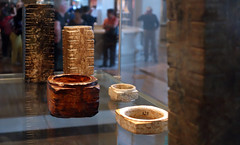
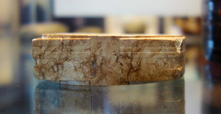
The Neolithic Period, defined as the age before the use of metal, witnessed a transition from a nomadic existence to one of settled farming. People made different pottery and stone tools in their regional communities. Stone workers employed jade to make prestigious, beautifully polished versions of utilitarian stone tools, such as axes, and also to make implements with possible ceremonial or protective functions. The status of jade continues throughout Chinese history. Pottery also reached a high level with the introduction of the potter’s wheel.
Neolithic Liangzhu culture
A group of Neolithic peoples grouped today as the Liangzhu culture lived in the Jiangsu province of China during the third millennium B.C.E. Their jades, ceramics and stone tools were highly sophisticated.
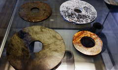
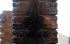
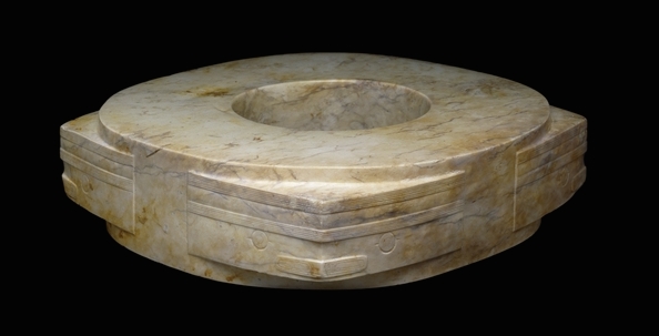
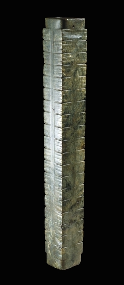
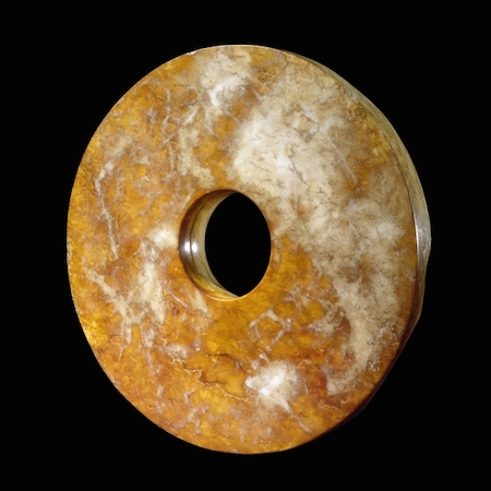
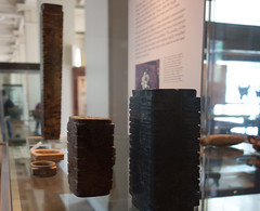
Cong
They used two distinct types of ritual jade objects: a disc, later known as a bi, and a tube, later known as a cong. The main types of cong have a square outer section around a circular inner part, and a circular hole, though jades of a bracelet shape also display some of the characteristics of cong. They clearly had great significance, but despite the many theories the meaning and purpose of bi and cong remain a mystery. They were buried in large numbers: one tomb alone had 25 bi and 33 cong. Spectacular examples have been found at all the major archaeological sites.
The principal decoration on cong of the Liangzhu period was the face pattern, which may refer to spirits or deities. On the square-sectioned pieces, like the examples here, the face pattern is placed across the corners, whereas on the bracelet form it appears in square panels. These faces are derived from a combination of a man-like figure and a mysterious beast.
Cong are among the most impressive yet most enigmatic of all ancient Chinese jade artifacts. Their function and meaning are completely unknown. Although they were made at many stages of the Neolithic and early historic period, the origin of the cong in the Neolithic cultures of south-east China has only been recognized in the last thirty years.
Cong were extremely difficult and time-consuming to produce. As jade cannot be split like other stones, it must be worked with a hard abrasive sand. This one is exceptionally long and may have been particularly important in its time.
Bi
Stone rings were being made by the peoples of eastern China as early as the fifth millennium B.C.E. Jade discs have been found carefully laid on the bodies of the dead in tombs of the Hongshan culture (about 3800-2700 B.C.E.), a practice which was continued by later Neolithic cultures. Large and heavy jade discs such as this example, appear to have been an innovation of the Liangzhu culture (about 3000-2000 B.C.E.), although they are not found in all major Liangzhu tombs. The term bi is applied to wide discs with proportionately small central holes.
The most finely carved discs or bi of the best stone (like the example above) were placed in prominent positions, often near the stomach and the chest of the deceased. Other bi were aligned with the body. Where large numbers of discs are found, usually in small piles, they tend to be rather coarse, made of stone of inferior quality that has been worked in a cursory way.
We do not know what the true significance of these discs was, but they must have had an important ritual function as part of the burial. This is an exceptionally fine example, because the two faces are very highly polished.
Suggested readings:
J. Rawson, Chinese Jade from the Neolithic to the Qing (London, The British Museum Press, 1995, reprinted 2002).
J. Rawson (ed.), The British Museum book of Chinese Art (London, The British Museum Press, 1992).
© Trustees of the British Museum
Smarthistory images for teaching and learning:


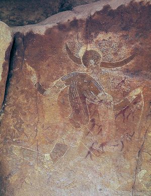
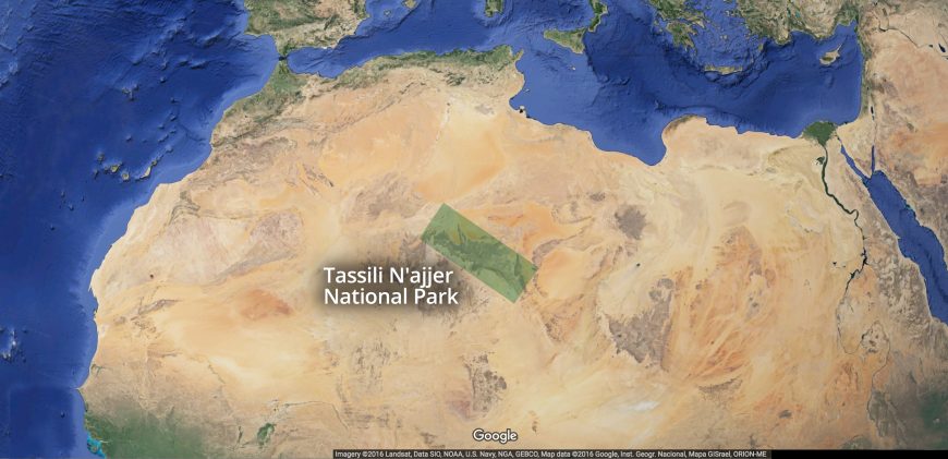
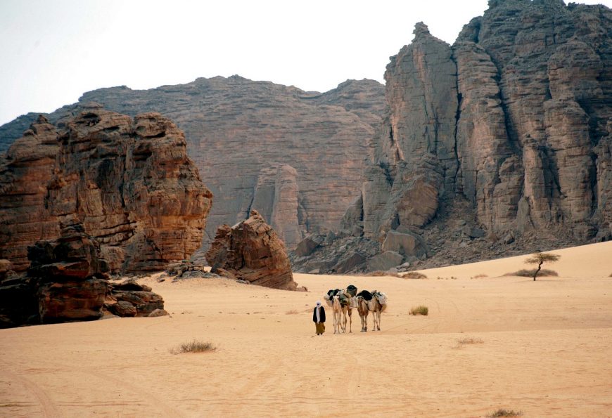
Running Horned Woman, Tassili n’Ajjer, Algeria
In an ancient North African “rock city,” modern explorers wetted a wall with water—revealing this graceful image.
“Discovery”
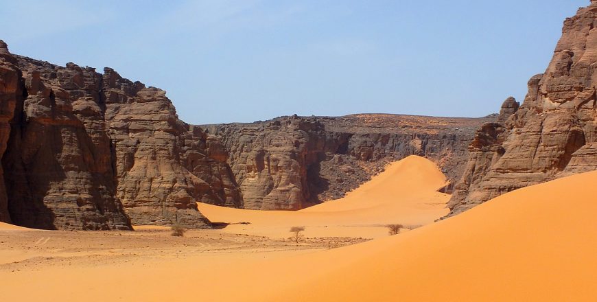
Between 1933 and 1940, camel corps officer Lieutenant Brenans of the French Foreign Legion completed a series of small sketches and hand written notes detailing his discovery of dozens of rock art sites deep within the canyons of the Tassili n’Ajjer. Tassili n’Ajjer is a difficult to access plateau in the Algerian section of the Sahara Desert near the borders of Libya and Niger in northern Africa (see map below). Brenans donated hundreds of his sketches to the Bardo Museum in Algiers, alerting the scientific community to one of the richest rock art concentrations on Earth and prompting site visits that included fellow Frenchman and archaeologist Henri Lhote.
Lhote recognized the importance of the region and returned again and again, most notably in 1956 with a team of copyists for a 16 month expedition to map and study the rock art of the Tassili. Two years later Lhote published A la découverte des fresques du Tassili. The book became an instant best-seller, and today is one of the most popular texts on archaeological discovery.
Lhote made African rock art famous by bringing some of the estimated 15,000 human figure and animal paintings and engravings found on the rock walls of the Tassili’s many gorges and shelters to the wider public. Yet contrary to the impression left by the title of his book, neither Lhote nor his team could lay claim to having discovered Central Saharan rock art: long before Lhote, and even before Brenans, in the late nineteenth century a number of travelers from Germany, Switzerland, and France had noted the existence of “strange” and “important” rock sculptures in Ghat, Tadrart Acacus, and Upper Tassili. But it was the Tuareg—the indigenous peoples of the region, many of whom served as guides to these early European explorers—who long knew of the paintings and engravings covering the rock faces of the Tassili.
The “Horned Goddess”
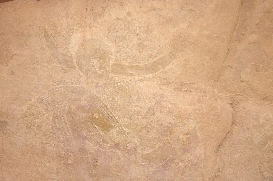
Lhote published not only reproductions of the paintings and engravings he found on the rock walls of the Tassili, but also his observations. In one excerpt he reported that with a can of water and a sponge in hand he set out to investigate a “curious figure” spotted by a member of his team in an isolated rock shelter located within a compact group of mountains known as the Aouanrhet massif, the highest of all the “rock cities” on the Tassili. Lhote swabbed the wall with water to reveal a figure he called the “Horned Goddess”:
On the damp rock surface stood out the gracious silhouette of a woman running. One of her legs, slightly flexed, just touched the ground, while the other was raised in the air as high as it would normally go. From the knees, the belt and the widely outstretched arms fell fine fringes. From either side of the head and above two horns that spread out horizontally was an extensive dotted area resembling a cloud of grain falling from a wheat field. Although the whole assemblage was skillfully and carefully composed there was something free and easy about it…
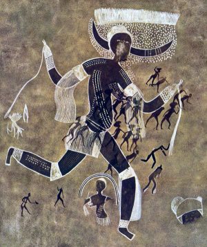
The Running Horned Woman, the title by which the painting is commonly known today, was found in a massif so secluded and so difficult to access that Lhote’s team concluded that the collection of shelters was likely a sanctuary and the female figure—“the most beautiful, the most finished and the most original”—a goddess:
Perhaps we have here the figure of a priestess of some agricultural religion or the picture of a goddess of such a cult who foreshadow—or is derived from—the goddess Isis, to whom, in Egypt, was attributed the discovery of agriculture.
Lhote’s suggestion that the painting’s source was Egyptian was influenced by a recently published hypothesis by his mentor, the French anthropologist Henri Breuil, the then undisputed authority on prehistoric rock art who was renowned for his work on Paleolithic cave art in Europe. In an essay titled, “The White Lady of Brandberg, South-West Africa, Her Companions and Her Guards,” Breuil famously claimed that a painting discovered in a small rock shelter in Namibia showed influences of Classical antiquity and was not African in origin, but possibly the work of Phoenician travellers from the Mediterranean. Lhote, equally convinced of outside influence, linked the Tassili painting’s provenance with Breuil’s ideas and revised the title to the ‘White Lady’ of Aouanrhet:
In other paintings found a few days later in the same massif we were able to discern, from some characteristic features, an indication of Egyptian influence. Some features are, no doubt, not very marked in our ‘White Lady’; still, all the same, some details as the curve of the breasts, led us to think that the picture may have been executed at a time when Egyptian traditions were beginning to be felt in the Tassili.
Foreign influence?
Time and scholarship would reveal that the assignment of Egyptian influence on the Running Horned Woman was erroneous, and Lhote the victim of a hoax: French members of his team made “copies” of Egyptionized figures, passing them off as faithful reproductions of authentic Tassili rock wall paintings. These fakes were accepted by Lhote (if indeed he knew nothing of the forgeries), and falsely sustained his belief in the possibility of foreign influence on Central Saharan rock art. Breuil’s theories were likewise discredited: the myth of the “White Lady” was rejected by every archaeologist of repute, and his promotion of foreign influence viewed as racist.
Yet Breuil and Lhote were not alone in finding it hard to believe that ancient Africans discovered how to make art on their own, or to have developed artistic sensibilities. Until quite recently many Europeans maintained that art “spread” or was “taken” into Africa, and, aiming to prove this thesis, anointed many works with Classical sounding names and sought out similarities with early rock art in Europe. Although such vestiges of colonial thinking are today facing a reckoning, cases such as the “White Lady” (both of Namibia and of Tassili) remind us of the perils of imposing cultural values from the outside.
Chronology
While we have yet to learn how, and in what places, the practice of rock art began, no firm evidence has been found to show that African rock art—some ten million images across the continent—was anything other than a spontaneous initiative by early Africans. Scholars have estimated the earliest art to date to 12,000 or more years ago, yet despite the use of both direct and indirect dating techniques very few firm dates exist (“direct dating” uses measurable physical and chemical analysis, such as radiocarbon dating, while “indirect dating” primarily uses associations from the archaeological context). In the north, where rock art tends to be quite diverse, research has focused on providing detailed descriptions of the art and placing works in chronological sequence based on style and content. This ordering approach results in useful classification and dating systems, dividing the Tassili paintings and engravings into periods of concurrent and overlapping traditions (the Running Horned Woman is estimated to date to approximately 6,000 to 4,000 B.C.E.—placing it within the “Round Head Period”), but offers little in the way of interpretation of the painting itself.
Advancing an interpretation of the Running Horned Woman
Who was the Running Horned Woman? Was she indeed a goddess, and her rock shelter some sort of sanctuary? What does the image mean? And why did the artist make it? For so long the search for meaning in rock art was considered inappropriate and unachievable—only recently have scholars endeavored to move beyond the mere description of images and styles, and, using a variety of interdisciplinary methods, make serious attempts to interpret the rock art of the Central Sahara.
Lhote recounted that the Running Horned Woman was found on an isolated rock whose base was hollowed out into a number of small shelters that could not have been used as dwellings. This remote location, coupled with an image of marked pictorial quality—depicting a female with two horns on her head, dots on her body probably representing scarification, and wearing such attributes of the dance as armlets and garters—suggested to him that the site, and the subject of the painting, fell outside of the everyday. More recent scholarship has supported Lhote’s belief in the painting’s symbolic, rather than literal, representation. As Jitka Soukopova has noted, “Hunter- gatherers were unlikely to wear horns (or other accessories on the head) and to make paintings on their whole bodies in their ordinary life.”[1] Rather, this female horned figure, her body adorned and decorated, found in one of the highest massifs in the Tassili—a region is believed to hold special status due to its elevation and unique topology—suggests ritual, rite, or ceremony. Rather, this female horned figure, her body adorned and decorated, found in one of the highest massifs in the Tassili—a region is believed to hold special status due to its elevation and unique topology—suggests ritual, rite, or ceremony.
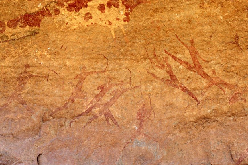
But there is further work to be done to advance an interpretation of the Running Horned Woman. Increasingly scholars have studied rock shelter sites as a whole, rather than isolating individual depictions, and the shelter’s location relative to the overall landscape and nearby water courses, in order to learn the significance of various “rock cities” in both image making and image viewing.
Archaeological data from decorated pottery, which is a dated artistic tradition, is key in suggesting that the concept of art was firmly established in the Central Sahara at the time of Tassili rock art production. Comparative studies with other rock art complexes, specifically the search for similarities in fundamental concepts in African religious beliefs, might yield the most fruitful approaches to interpretation. In other words, just as southern African rock studies have benefitted from tracing the beliefs and practices of the San people, so too may a study of Tuareg ethnography shed light on the ancient rock art sites of the Tassili.
Afterword: the threatened rock art of the Central Sahara
Tassili’s rock walls were commonly sponged with water in order to enhance the reproduction of its images, either in trace, sketch, or photograph. This washing of the rock face has had a devastating effect on the art, upsetting the physical, chemical, and biological balance of the images and their rock supports. Many of the region’s subsequent visitors—tourists, collectors, photographers, and the next generation of researchers—all captivated by Lhote’s “discovery”—have continued the practice of moistening the paintings in order to reveal them. Today scholars report paintings that are severely faded while some have simply disappeared. In addition, others have suffered from irreversible damage caused by outright vandalism: art looted or stolen as souvenirs. In order to protect this valuable center of African rock art heritage, Tassili N’Ajjer was declared a National Park in 1972. It was classified as a World Heritage Site by UNESCO in 1982 and a Biosphere Reserve in 1986.
[1] Jitka Soukopova, “The Earliest Rock Paintings of the Central Sahara: Approaching Interpretation,” Time and Mind: The Journal of Archaeology, Consciousness and Culture 4, no. 2 (2011), p. 199.
Additional resources
African Rock Art: TassilinAjjer – Heilbrunn Timeline of Art History
Tassili n’Ajjer – African World Heritage Sites
TARA – Trust for African Rock Art: Algeria and TARA Interactive Rock Art Map
David Coulson and Alec Campbell, African Rock Art: Paintings and Engravings on Stone (New York: Harry N. Abrams, Inc., 2001).
David Coulson and Alec Campbell, “Rock Art of the Tassili n Ajjer, Algeria.” Adoranten, no. 1 (2010), p. 115.
Jeremy H. Keenan, “The Lesser Gods of the Sahara.” Public Archaeology 2, no. 3 (2002), pp. 131-50.
Jean Dominque Lajoux, The Rock Paintings of Tassili, translated by G. D. Liversage (London: Thames and Hudson, 1963).
Henri Lhote, The Search for the Tassili Frescoes, translated by Alan H. Brodrick (London: Hutchinson & Co., 1959).
Rock-Art Sites of Tadrart Acacus (Libya)
by UNESCO
Images on rocks in the Sahara provide a glimpse into the development of humans in this now barren land.
Video \(\PageIndex{10}\): On the borders of Tassili N’Ajjer in Algeria, also a World Heritage site, this rocky massif has thousands of cave paintings in very different styles, dating from 12,000 B.C. to A.D. 100. They reflect marked changes in the fauna and flora, and also the different ways of life of the populations that succeeded one another in this region of the Sahara. Video from UNESCO
Backstory
The rock art sites of Tadrart Acacus have survived for 14,000 years in the desert of southern Libya, but they are now under serious threat. Since 2009, vandalism has been a continuous problem: graffiti has been spray-painted across the surface of many of the paintings, and people have carved their initials into the rocks. But despite UNESCO’s and other organizations’ calls for the government to intervene with restoration and security measures, efforts to protect this precious ancient site have been gravely hampered by armed conflict and political chaos.
Libya experienced a political revolution in 2011 with the ousting of Muammar Gaddafi, and since then the country has been in a state of civil war. Savino di Lernia, an archaeologist at Sapienza University of Rome who has worked extensively in the Tadrart Acacus mountains, explains how dangerous the area—formerly a tourist destination—has become:
Today, the site is inaccessible: no commercial flight connects Tripoli and Ghat, a nearby town (a weekly military aircraft brings food, essential goods and first-aid equipment). The tarred road between Ghat and Ubari is broken up, and clashes between the Tebu and Tuareg tribes increasingly affect the area….Being a Saharan archaeologist today is a difficult job. Researchers fear being kidnapped or even killed.
Yahya Saleh, a local tour guide, mourns the fact that local hunters now regularly scrawl their names across the art: “People do not know the value of this. There are supposed to be people to protect these areas…because if this issue persists, then they will be gone within two years.”
The ongoing vandalism of the Tadrart Acacus sites is only one of the many overwhelming difficulties Libya faces with regard to cultural heritage protection. As di Lernia notes,
Perhaps the greatest threat to Libya’s diverse heritage is the trafficking of archaeological materials, for profit or to fund radical groups….No one has been able to fully assess the situation in Libya. Going to work among the black smoke of grenades, the men and women of the Libyan Department of Antiquities are doing their best. But museums are closed and the little activity left in the field is limited to the north.
Until the fighting in Libya stops and archaeologists can again effectively cooperate with the government and international organizations to restore and protect sites like the rock art at Tadrart Acacus, Libya’s rich trove of monuments and artifacts will continue to be endangered.
Backstory by Dr. Naraelle Hohensee
Additional resources:
Another UNESCO video, on rock art in Tassili n’Ajjer
UNESCO webpage for Tadrart Acacus
UNESCO report on the state of conservation at Tadrart Acacus
Ulf Leassig, “Vandals destroy prehistoric rock art in Libya’s lawless Sahara,” Reuters, June 3, 2014
Savino di Lernia, “Cultural heritage: Save Libyan archaeology,” Nature, January 28, 2015
Report on Tadrart Acacus rock art from the AP Archive, January, 2018
Rock Art in the Green Sahara (Neolithic)
Rock art is one of the best records of the life of past peoples who lived across the Sahara.
Video \(\PageIndex{11}\): Video from The British Museum
The Sahara is the world’s largest hot desert, spanning the entire northern part of Africa. Yet it hasn’t always been dry — archaeological and geological research shows that it has undergone major climatic changes over thousands of years. Rock art often depicts extraordinary images of life, landscape and animals that show a time when the Sahara was much greener and wetter than it is now.
This film is in collaborative partnership with the Leverhulme Trust-funded project: “Peopling the Green Sahara. A multi-proxy approach to reconstructing the ecological and demographic history of the Saharan Holocene”, Paul Breeze, Nick Drake and Katie Manning, Department of Geography, King’s College London Modelling and mapping of the Green Sahara ©Kings College London Images ©Trust for African Rock Art (TARA)/David Coulson & ©Kings College London